Otelec geodata
Otelec (Timiş) is a seat of a second-order administrative division; located in Romania in Europe/Bucharest (GMT+3) time zone. With population of 823 people, there are 4942 cities with bigger population in this country. Compared to other cities in Romania, 53.4% of cities are located further ↑North; 99.6% of cities are located further →East and 85.7% of cities have higher elevation than Otelec. Note1


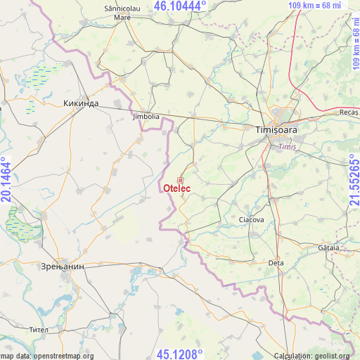
Otelec GPS coordinates[2]
45° 36' 53.208" North, 20° 50' 58.272" East
| Map corner | latitude | longitude |
|---|---|---|
| Upper-left | 46.10444°, | 20.1464° |
| Center: | 45.61478°, | 20.84952° |
| Lower-right: | 45.1208°, | 21.55265° |
| Map W x H: | 109.4×109.4 km | = 68×68mi |
| max Lat: | 48.23793° ⇑53.4% North |
| Otelec: | 45.61478° |
| min Lat: | ⇓46.6% South 43.65638° |
| min Long | Otelec | max Long |
| 20.31667° | 20.84952° | 29.65403° |
| W 0.4%⇐ | ⇒99.6% E |
Elevation
Elevation of Otelec is 76 m = 249 ft, and this is 178.9 m = 587 ft below average elevation for this country.
| Max E: |
1278 m = 4193 ft | 85.7% |
| Avg. | 254.9 m = 836 ft | |
| Otelec | 76 m = 249 ft | |
Min E: |
-2 m = -7 ft | 14.3% |
See also: Romania elevation on elevation.city.
Geographical zone
Otelec is located in North temperate zone (between Tropic of Cancer and the Arctic Circle). Distance of this North polar circle is 2329.3 km =1447.4 mi to North.| Distance of | km | miles | from Otelec |
|---|---|---|---|
| North Pole | 4935.2 | 3066.6 | to North |
| Arctic Circle | 2329.3 | 1447.4 | to North |
| Tropic Cancer | 2466 | 1532.3 | to South |
| Equator | 5071.9 | 3151.5 | to South |


Nearby cities:
15 places around Otelec: (largest is in red/bold)
• Bobda
15.5 km =9.6 mi,  29°
29°
• Cenei
12 km =7.5 mi,  20°
20°
• Checea
15.4 km =9.6 mi,  356°
356°
• Diniaș
12.8 km =8 mi,  71°
71°
• Foeni
13.1 km =8.1 mi,  170°
170°
• Giulvăz
12.8 km =8 mi,  124°
124°
• Iohanisfeld
5.4 km =3.4 mi, 168°
• Ivanda
9 km =5.6 mi,  127°
127°
• Peciu Nou
16.2 km =10.1 mi,  93°
93°
• Pustiniș
2.3 km =1.4 mi, 16°
• Rudna
17.9 km =11.1 mi,  136°
136°
• Răuți
9.2 km =5.7 mi,  44°
44°
• Sânmartinu Sârbesc
8.6 km =5.3 mi,  96°
96°
• Sânmihaiu German
17.7 km =11 mi,  52°
52°
• Uivar
6.5 km =4 mi, 42°
Sources, notices
• [Note1] Compared only with cities in Romania existing in our database
• [Src1] Map data: © OpenStreetMap contributors (CC-BY-SA)
• [Src2] Other city data from geonames.org with taken over terms of usage.
• [Src3] Geographical zone / Annual Mean Temperature by Robert A. Rohde @ Wikipedia
