Uivar geodata
Uivar (Timiş) is a seat of a second-order administrative division; located in Romania in Europe/Bucharest (GMT+3) time zone. With population of 4,378 people, there are 1009 cities with bigger population in this country. Compared to other cities in Romania, 52.7% of cities are located further ↑North; 99.5% of cities are located further →East and 84.4% of cities have higher elevation than Uivar. Note1


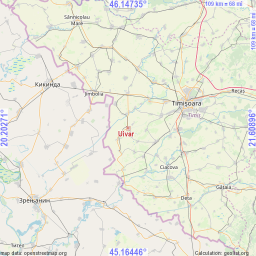
Uivar GPS coordinates[2]
45° 39' 29.016" North, 20° 54' 20.988" East
| Map corner | latitude | longitude |
|---|---|---|
| Upper-left | 46.14735°, | 20.20271° |
| Center: | 45.65806°, | 20.90583° |
| Lower-right: | 45.16446°, | 21.60896° |
| Map W x H: | 109.3×109.3 km | = 67.9×67.9mi |
| max Lat: | 48.23793° ⇑52.7% North |
| Uivar: | 45.65806° |
| min Lat: | ⇓47.3% South 43.65638° |
| min Long | Uivar | max Long |
| 20.31667° | 20.90583° | 29.65403° |
| W 0.5%⇐ | ⇒99.5% E |
Elevation
Elevation of Uivar is 80 m = 262 ft, and this is 174.9 m = 574 ft below average elevation for this country.
| Max E: |
1278 m = 4193 ft | 84.4% |
| Avg. | 254.9 m = 836 ft | |
| Uivar | 80 m = 262 ft | |
Min E: |
-2 m = -7 ft | 15.6% |
See also: Romania elevation on elevation.city.
Geographical zone
Uivar is located in North temperate zone (between Tropic of Cancer and the Arctic Circle). Distance of this North polar circle is 2324.5 km =1444.4 mi to North.| Distance of | km | miles | from Uivar |
|---|---|---|---|
| North Pole | 4930.4 | 3063.6 | to North |
| Arctic Circle | 2324.5 | 1444.4 | to North |
| Tropic Cancer | 2470.8 | 1535.3 | to South |
| Equator | 5076.7 | 3154.5 | to South |


Nearby cities:
15 places around Uivar: (largest is in red/bold)
• Beregsău Mic
11.8 km =7.3 mi,  28°
28°
• Bobda
9.3 km =5.8 mi,  20°
20°
• Cenei
6.4 km =4 mi,  358°
358°
• Checea
11.9 km =7.4 mi,  332°
332°
• Cărpiniş
14.4 km =8.9 mi, 359°
• Diniaș
7.8 km =4.8 mi,  95°
95°
• Giulvăz
13.6 km =8.5 mi,  153°
153°
• Iohanisfeld
10.7 km =6.6 mi,  197°
197°
• Ivanda
10.6 km =6.6 mi,  164°
164°
• Otelec
6.5 km =4 mi,  222°
222°
• Peciu Nou
13.1 km =8.1 mi,  115°
115°
• Pustiniș
4.6 km =2.9 mi,  234°
234°
• Răuți
2.7 km =1.7 mi,  51°
51°
• Sânmartinu Sârbesc
7.1 km =4.4 mi,  144°
144°
• Sânmihaiu German
11.3 km =7 mi,  58°
58°
Sources, notices
• [Note1] Compared only with cities in Romania existing in our database
• [Src1] Map data: © OpenStreetMap contributors (CC-BY-SA)
• [Src2] Other city data from geonames.org with taken over terms of usage.
• [Src3] Geographical zone / Annual Mean Temperature by Robert A. Rohde @ Wikipedia
