Cerchezu geodata
Cerchezu (Constanța) is a seat of a second-order administrative division; located in Romania in Europe/Bucharest (GMT+3) time zone. With population of 1,548 people, there are 3115 cities with bigger population in this country. Compared to other cities in Romania, 99.3% of cities are located further ↑North; 97.2% of cities are located further ←West and 68.7% of cities have higher elevation than Cerchezu. Note1


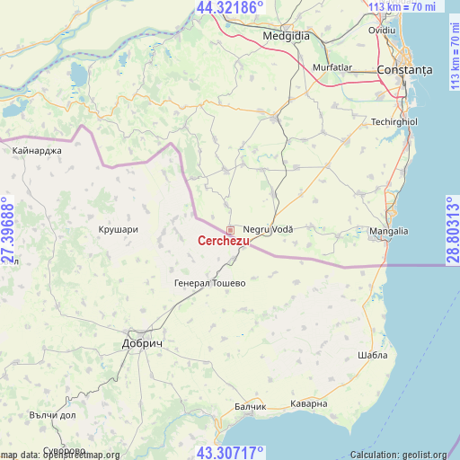
Cerchezu GPS coordinates[2]
43° 49' 0.012" North, 28° 6' 0" East
| Map corner | latitude | longitude |
|---|---|---|
| Upper-left | 44.32186°, | 27.39688° |
| Center: | 43.81667°, | 28.1° |
| Lower-right: | 43.30717°, | 28.80313° |
| Map W x H: | 112.8×112.8 km | = 70.1×70.1mi |
| max Lat: | 48.23793° ⇑99.3% North |
| Cerchezu: | 43.81667° |
| min Lat: | ⇓0.7% South 43.65638° |
| min Long | Cerchezu | max Long |
| 20.31667° | 28.1° | 29.65403° |
| W 97.2%⇐ | ⇒2.8% E |
Elevation
Elevation of Cerchezu is 132 m = 433 ft, and this is 122.9 m = 403 ft below average elevation for this country.
| Max E: |
1278 m = 4193 ft | 68.7% |
| Avg. | 254.9 m = 836 ft | |
| Cerchezu | 132 m = 433 ft | |
Min E: |
-2 m = -7 ft | 31.3% |
See also: Romania elevation on elevation.city.
Geographical zone
Cerchezu is located in North temperate zone (between Tropic of Cancer and the Arctic Circle). Distance of this Northern Tropic circle is 2266 km =1408 mi to South.| Distance of | km | miles | from Cerchezu |
|---|---|---|---|
| North Pole | 5135.1 | 3190.8 | to North |
| Arctic Circle | 2529.2 | 1571.6 | to North |
| Tropic Cancer | 2266 | 1408 | to South |
| Equator | 4872 | 3027.3 | to South |


Nearby cities:
15 places around Cerchezu: (largest is in red/bold)
• Albeşti
25.5 km =15.8 mi,  94°
94°
• Chirnogeni
14.1 km =8.8 mi,  49°
49°
• Comana
19.7 km =12.2 mi,  61°
61°
• Cotu Văii
19.8 km =12.3 mi, 87°
• Darabani
16.1 km =10 mi,  101°
101°
• Dumbrăveni
16 km =9.9 mi,  324°
324°
• General Scărișoreanu
22.2 km =13.8 mi, 46°
• Independenţa
16.7 km =10.4 mi,  355°
355°
• Movila Verde
16.6 km =10.3 mi,  11°
11°
• Negrești
20.5 km =12.7 mi, 7°
• Negru Vodă
8 km =5 mi, 90°
• Petroșani
22.3 km =13.9 mi,  350°
350°
• Plopeni
16.7 km =10.4 mi,  26°
26°
• Tătaru
22.1 km =13.7 mi,  71°
71°
• Viroaga
6.2 km =3.9 mi, 351°
Sources, notices
• [Note1] Compared only with cities in Romania existing in our database
• [Src1] Map data: © OpenStreetMap contributors (CC-BY-SA)
• [Src2] Other city data from geonames.org with taken over terms of usage.
• [Src3] Geographical zone / Annual Mean Temperature by Robert A. Rohde @ Wikipedia
