Cajvana geodata
Cajvana (Suceava) is a seat of a second-order administrative division; located in Romania in Europe/Bucharest (GMT+3) time zone. With population of 7,236 people, there are 373 cities with bigger population in this country. Compared to other cities in Romania, 94.9% of cities are located further ↓South; 62.2% of cities are located further ←West and 79.6% of cities have lower elevation than Cajvana. Note1


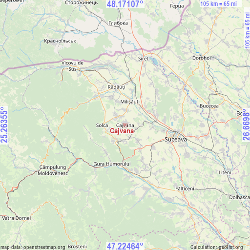
Cajvana GPS coordinates[2]
47° 42' 0" North, 25° 58' 0.012" East
| Map corner | latitude | longitude |
|---|---|---|
| Upper-left | 48.17107°, | 25.26355° |
| Center: | 47.7°, | 25.96667° |
| Lower-right: | 47.22464°, | 26.6698° |
| Map W x H: | 105.2×105.2 km | = 65.4×65.4mi |
| max Lat: | 48.23793° ⇑5.1% North |
| Cajvana: | 47.7° |
| min Lat: | ⇓94.9% South 43.65638° |
| min Long | Cajvana | max Long |
| 20.31667° | 25.96667° | 29.65403° |
| W 62.2%⇐ | ⇒37.8% E |
Elevation
Elevation of Cajvana is 389 m = 1276 ft, and this is 134.1 m = 440 ft above average elevation for this country.
| Max E: |
1278 m = 4193 ft | 20.4% |
| Cajvana | 389 m 1276 ft | |
| Avg. | 254.9 m = 836 ft | |
Min E: |
-2 m = -7 ft | 79.6% |
See also: Romania elevation on elevation.city.
Geographical zone
Cajvana is located in North temperate zone (between Tropic of Cancer and the Arctic Circle). Distance of this North polar circle is 2097.4 km =1303.3 mi to North.| Distance of | km | miles | from Cajvana |
|---|---|---|---|
| North Pole | 4703.3 | 2922.5 | to North |
| Arctic Circle | 2097.4 | 1303.3 | to North |
| Tropic Cancer | 2697.8 | 1676.3 | to South |
| Equator | 5303.7 | 3295.6 | to South |


Nearby cities:
15 places around Cajvana: (largest is in red/bold)
• Arbore
4.5 km =2.8 mi,  326°
326°
• Botoşana
2.2 km =1.4 mi,  213°
213°
• Bălăceana
8.7 km =5.4 mi,  136°
136°
• Cacica
8.9 km =5.5 mi, 213°
• Comănești
3.8 km =2.4 mi,  154°
154°
• Deleni
7.9 km =4.9 mi,  175°
175°
• Gura Solcii
7.7 km =4.8 mi,  53°
53°
• Humoreni
3.9 km =2.4 mi,  161°
161°
• Iaslovăț
6.6 km =4.1 mi,  7°
7°
• Poieni-Solca
5.7 km =3.5 mi,  254°
254°
• Părteştii de Jos
7.4 km =4.6 mi, 180°
• Slobozia Sucevei
9.3 km =5.8 mi,  39°
39°
• Solca
8.7 km =5.4 mi,  270°
270°
• Soloneț
5.1 km =3.2 mi,  106°
106°
• Todireşti
5 km =3.1 mi,  90°
90°
Sources, notices
• [Note1] Compared only with cities in Romania existing in our database
• [Src1] Map data: © OpenStreetMap contributors (CC-BY-SA)
• [Src2] Other city data from geonames.org with taken over terms of usage.
• [Src3] Geographical zone / Annual Mean Temperature by Robert A. Rohde @ Wikipedia
