Obârșia geodata
Obârșia (Gorj) is a populated place; located in Romania in Europe/Bucharest (GMT+3) time zone. With population of 629 people, there are 6012 cities with bigger population in this country. Compared to other cities in Romania, 76.2% of cities are located further ↑North; 73.1% of cities are located further →East and 67.9% of cities have lower elevation than Obârșia. Note1


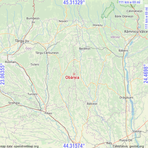
Obârșia GPS coordinates[2]
44° 49' 0.012" North, 23° 46' 0.012" East
| Map corner | latitude | longitude |
|---|---|---|
| Upper-left | 45.31329°, | 23.06355° |
| Center: | 44.81667°, | 23.76667° |
| Lower-right: | 44.31574°, | 24.4698° |
| Map W x H: | 110.9×110.9 km | = 68.9×68.9mi |
| max Lat: | 48.23793° ⇑76.2% North |
| Obârșia: | 44.81667° |
| min Lat: | ⇓23.8% South 43.65638° |
| min Long | Obârșia | max Long |
| 20.31667° | 23.76667° | 29.65403° |
| W 26.9%⇐ | ⇒73.1% E |
Elevation
Elevation of Obârșia is 306 m = 1004 ft, and this is 51.1 m = 168 ft above average elevation for this country.
| Max E: |
1278 m = 4193 ft | 32.1% |
| Obârșia | 306 m 1004 ft | |
| Avg. | 254.9 m = 836 ft | |
Min E: |
-2 m = -7 ft | 67.9% |
See also: Romania elevation on elevation.city.
Geographical zone
Obârșia is located in North temperate zone (between Tropic of Cancer and the Arctic Circle). Distance of this Northern Tropic circle is 2377.2 km =1477.1 mi to South.| Distance of | km | miles | from Obârșia |
|---|---|---|---|
| North Pole | 5023.9 | 3121.7 | to North |
| Arctic Circle | 2418 | 1502.5 | to North |
| Tropic Cancer | 2377.2 | 1477.1 | to South |
| Equator | 4983.1 | 3096.4 | to South |


Nearby cities:
15 places around Obârșia: (largest is in red/bold)
• Baloșani
12.8 km =8 mi,  221°
221°
• Dănciuleşti
9.4 km =5.8 mi,  188°
188°
• Grădiştea
6.8 km =4.2 mi,  35°
35°
• Hurezani
9.4 km =5.8 mi,  258°
258°
• Linia
10.1 km =6.3 mi,  15°
15°
• Livezi
5.3 km =3.3 mi,  60°
60°
• Logreşti
10.7 km =6.6 mi,  330°
330°
• Logrești Moșteni
11.1 km =6.9 mi, 334°
• Negreni
10.3 km =6.4 mi,  287°
287°
• Piscoiu
4.1 km =2.5 mi,  345°
345°
• Rădinești
2.8 km =1.7 mi,  183°
183°
• Stejari
8.6 km =5.3 mi,  229°
229°
• Sășcioara
8.4 km =5.2 mi,  102°
102°
• Zătreni
8.6 km =5.3 mi,  130°
130°
• Țepești
12.6 km =7.8 mi, 102°
Sources, notices
• [Note1] Compared only with cities in Romania existing in our database
• [Src1] Map data: © OpenStreetMap contributors (CC-BY-SA)
• [Src2] Other city data from geonames.org with taken over terms of usage.
• [Src3] Geographical zone / Annual Mean Temperature by Robert A. Rohde @ Wikipedia
