Holdița geodata
Holdița (Suceava) is a populated place; located in Romania in Europe/Bucharest (GMT+3) time zone. With population of 541 people, there are 6671 cities with bigger population in this country. Compared to other cities in Romania, 85.6% of cities are located further ↓South; 57.5% of cities are located further ←West and 95.4% of cities have lower elevation than Holdița. Note1


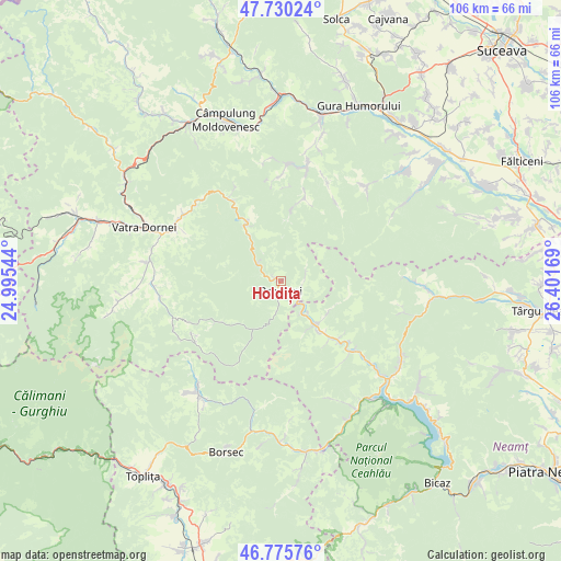
Holdița GPS coordinates[2]
47° 15' 18.54" North, 25° 41' 54.816" East
| Map corner | latitude | longitude |
|---|---|---|
| Upper-left | 47.73024°, | 24.99544° |
| Center: | 47.25515°, | 25.69856° |
| Lower-right: | 46.77576°, | 26.40169° |
| Map W x H: | 106.1×106.1 km | = 65.9×65.9mi |
| max Lat: | 48.23793° ⇑14.4% North |
| Holdița: | 47.25515° |
| min Lat: | ⇓85.6% South 43.65638° |
| min Long | Holdița | max Long |
| 20.31667° | 25.69856° | 29.65403° |
| W 57.5%⇐ | ⇒42.5% E |
Elevation
Elevation of Holdița is 641 m = 2103 ft, and this is 386.1 m = 1267 ft above average elevation for this country.
| Max E: |
1278 m = 4193 ft | 4.6% |
| Holdița | 641 m 2103 ft | |
| Avg. | 254.9 m = 836 ft | |
Min E: |
-2 m = -7 ft | 95.4% |
See also: Romania elevation on elevation.city.
Geographical zone
Holdița is located in North temperate zone (between Tropic of Cancer and the Arctic Circle). Distance of this North polar circle is 2146.9 km =1334 mi to North.| Distance of | km | miles | from Holdița |
|---|---|---|---|
| North Pole | 4752.8 | 2953.3 | to North |
| Arctic Circle | 2146.9 | 1334 | to North |
| Tropic Cancer | 2648.4 | 1645.6 | to South |
| Equator | 5254.3 | 3264.9 | to South |


Nearby cities:
15 places around Holdița: (largest is in red/bold)
• Borca
9.5 km =5.9 mi,  147°
147°
• Broşteni
2.4 km =1.5 mi,  177°
177°
• Crucea
12.2 km =7.6 mi,  329°
329°
• Fărcaşa
14.2 km =8.8 mi,  134°
134°
• Holda
1.6 km =1 mi,  298°
298°
• Mădei
6.9 km =4.3 mi,  144°
144°
• Neagra
2.1 km =1.3 mi, 178°
• Ostra
16.9 km =10.5 mi,  17°
17°
• Popești
17.4 km =10.8 mi, 131°
• Pârâul Cârjei
8 km =5 mi, 140°
• Pârâul Pântei
13.3 km =8.3 mi, 137°
• Sabasa
10.8 km =6.7 mi,  123°
123°
• Soci
11.8 km =7.3 mi, 143°
• Stejaru
14.3 km =8.9 mi, 138°
• Vadu Negrilesei
18 km =11.2 mi,  36°
36°
Sources, notices
• [Note1] Compared only with cities in Romania existing in our database
• [Src1] Map data: © OpenStreetMap contributors (CC-BY-SA)
• [Src2] Other city data from geonames.org with taken over terms of usage.
• [Src3] Geographical zone / Annual Mean Temperature by Robert A. Rohde @ Wikipedia
