Holda geodata
Holda (Suceava) is a populated place; located in Romania in Europe/Bucharest (GMT+3) time zone. With population of 932 people, there are 4506 cities with bigger population in this country. Compared to other cities in Romania, 85.7% of cities are located further ↓South; 57.2% of cities are located further ←West and 95.6% of cities have lower elevation than Holda. Note1


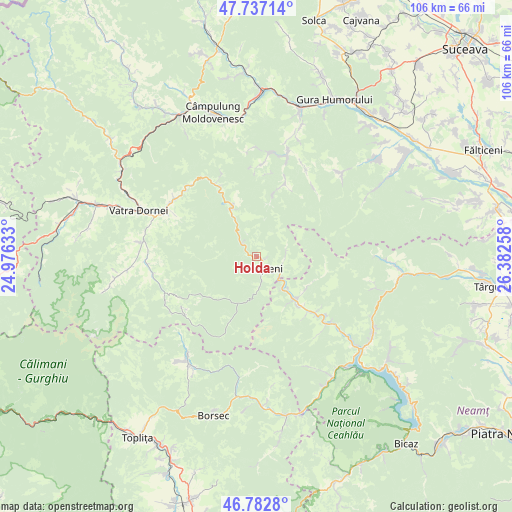
Holda GPS coordinates[2]
47° 15' 43.632" North, 25° 40' 46.02" East
| Map corner | latitude | longitude |
|---|---|---|
| Upper-left | 47.73714°, | 24.97633° |
| Center: | 47.26212°, | 25.67945° |
| Lower-right: | 46.7828°, | 26.38258° |
| Map W x H: | 106.1×106.1 km | = 65.9×65.9mi |
| max Lat: | 48.23793° ⇑14.3% North |
| Holda: | 47.26212° |
| min Lat: | ⇓85.7% South 43.65638° |
| min Long | Holda | max Long |
| 20.31667° | 25.67945° | 29.65403° |
| W 57.2%⇐ | ⇒42.8% E |
Elevation
Elevation of Holda is 646 m = 2119 ft, and this is 391.1 m = 1283 ft above average elevation for this country.
| Max E: |
1278 m = 4193 ft | 4.4% |
| Holda | 646 m 2119 ft | |
| Avg. | 254.9 m = 836 ft | |
Min E: |
-2 m = -7 ft | 95.6% |
See also: Romania elevation on elevation.city.
Geographical zone
Holda is located in North temperate zone (between Tropic of Cancer and the Arctic Circle). Distance of this North polar circle is 2146.1 km =1333.5 mi to North.| Distance of | km | miles | from Holda |
|---|---|---|---|
| North Pole | 4752 | 2952.8 | to North |
| Arctic Circle | 2146.1 | 1333.5 | to North |
| Tropic Cancer | 2649.1 | 1646.1 | to South |
| Equator | 5255.1 | 3265.4 | to South |


Nearby cities:
15 places around Holda: (largest is in red/bold)
• Borca
11 km =6.8 mi,  143°
143°
• Broşteni
3.6 km =2.2 mi,  154°
154°
• Crucea
10.9 km =6.8 mi,  334°
334°
• Fărcaşa
15.7 km =9.8 mi,  132°
132°
• Holdița
1.6 km =1 mi,  118°
118°
• Mădei
8.4 km =5.2 mi, 139°
• Neagra
3.3 km =2.1 mi, 152°
• Ostra
16.7 km =10.4 mi,  23°
23°
• Popești
19 km =11.8 mi, 130°
• Pârâul Cârjei
9.5 km =5.9 mi, 136°
• Pârâul Pântei
14.8 km =9.2 mi, 135°
• Sabasa
12.4 km =7.7 mi, 122°
• Soci
13.3 km =8.3 mi, 140°
• Stejaru
15.9 km =9.9 mi, 136°
• Vadu Negrilesei
18.3 km =11.4 mi,  41°
41°
Sources, notices
• [Note1] Compared only with cities in Romania existing in our database
• [Src1] Map data: © OpenStreetMap contributors (CC-BY-SA)
• [Src2] Other city data from geonames.org with taken over terms of usage.
• [Src3] Geographical zone / Annual Mean Temperature by Robert A. Rohde @ Wikipedia
