Hăghig geodata
Hăghig (Covasna) is a seat of a second-order administrative division; located in Romania in Europe/Bucharest (GMT+3) time zone. With population of 2,175 people, there are 2448 cities with bigger population in this country. Compared to other cities in Romania, 51% of cities are located further ↓South; 55.8% of cities are located further ←West and 88.1% of cities have lower elevation than Hăghig. Note1


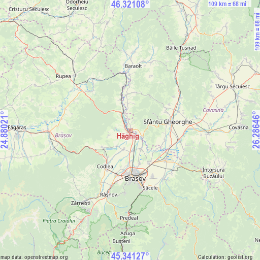
Hăghig GPS coordinates[2]
45° 49' 59.988" North, 25° 34' 59.988" East
| Map corner | latitude | longitude |
|---|---|---|
| Upper-left | 46.32108°, | 24.88021° |
| Center: | 45.83333°, | 25.58333° |
| Lower-right: | 45.34127°, | 26.28646° |
| Map W x H: | 108.9×108.9 km | = 67.7×67.7mi |
| max Lat: | 48.23793° ⇑49% North |
| Hăghig: | 45.83333° |
| min Lat: | ⇓51% South 43.65638° |
| min Long | Hăghig | max Long |
| 20.31667° | 25.58333° | 29.65403° |
| W 55.8%⇐ | ⇒44.2% E |
Elevation
Elevation of Hăghig is 485 m = 1591 ft, and this is 230.1 m = 755 ft above average elevation for this country.
| Max E: |
1278 m = 4193 ft | 11.9% |
| Hăghig | 485 m 1591 ft | |
| Avg. | 254.9 m = 836 ft | |
Min E: |
-2 m = -7 ft | 88.1% |
See also: Romania elevation on elevation.city.
Geographical zone
Hăghig is located in North temperate zone (between Tropic of Cancer and the Arctic Circle). Distance of this North polar circle is 2305 km =1432.3 mi to North.| Distance of | km | miles | from Hăghig |
|---|---|---|---|
| North Pole | 4910.9 | 3051.5 | to North |
| Arctic Circle | 2305 | 1432.3 | to North |
| Tropic Cancer | 2490.3 | 1547.4 | to South |
| Equator | 5096.2 | 3166.6 | to South |


Nearby cities:
15 places around Hăghig: (largest is in red/bold)
• Araci
6 km =3.7 mi,  113°
113°
• Arini
6.1 km =3.8 mi,  347°
347°
• Belin
11.2 km =7 mi, 353°
• Belin-Vale
11.2 km =7 mi,  10°
10°
• Bod
9 km =5.6 mi,  145°
145°
• Colonia Bod
8.7 km =5.4 mi,  171°
171°
• Colonia Reconstrucția
1.2 km =0.7 mi,  232°
232°
• Crizbav
9.2 km =5.7 mi,  257°
257°
• Cutuș
9 km =5.6 mi, 264°
• Feldioara
2.3 km =1.4 mi, 145°
• Hălchiu
7.8 km =4.8 mi,  199°
199°
• Măieruş
8.4 km =5.2 mi,  332°
332°
• Podu Oltului
13.5 km =8.4 mi,  126°
126°
• Rotbav
2.1 km =1.3 mi,  287°
287°
• Vâlcele
8 km =5 mi,  76°
76°
Sources, notices
• [Note1] Compared only with cities in Romania existing in our database
• [Src1] Map data: © OpenStreetMap contributors (CC-BY-SA)
• [Src2] Other city data from geonames.org with taken over terms of usage.
• [Src3] Geographical zone / Annual Mean Temperature by Robert A. Rohde @ Wikipedia
