Vâlcele geodata
Vâlcele (Covasna) is a seat of a second-order administrative division; located in Romania in Europe/Bucharest (GMT+3) time zone. With population of 3,646 people, there are 1351 cities with bigger population in this country. Compared to other cities in Romania, 51.4% of cities are located further ↓South; 57.3% of cities are located further ←West and 95.4% of cities have lower elevation than Vâlcele. Note1


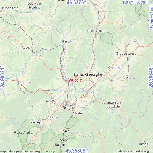
Vâlcele GPS coordinates[2]
45° 51' 0" North, 25° 40' 59.988" East
| Map corner | latitude | longitude |
|---|---|---|
| Upper-left | 46.3376°, | 24.98021° |
| Center: | 45.85°, | 25.68333° |
| Lower-right: | 45.35809°, | 26.38646° |
| Map W x H: | 108.9×108.9 km | = 67.7×67.7mi |
| max Lat: | 48.23793° ⇑48.6% North |
| Vâlcele: | 45.85° |
| min Lat: | ⇓51.4% South 43.65638° |
| min Long | Vâlcele | max Long |
| 20.31667° | 25.68333° | 29.65403° |
| W 57.3%⇐ | ⇒42.7% E |
Elevation
Elevation of Vâlcele is 640 m = 2100 ft, and this is 385.1 m = 1263 ft above average elevation for this country.
| Max E: |
1278 m = 4193 ft | 4.6% |
| Vâlcele | 640 m 2100 ft | |
| Avg. | 254.9 m = 836 ft | |
Min E: |
-2 m = -7 ft | 95.4% |
See also: Romania elevation on elevation.city.
Geographical zone
Vâlcele is located in North temperate zone (between Tropic of Cancer and the Arctic Circle). Distance of this North polar circle is 2303.1 km =1431.1 mi to North.| Distance of | km | miles | from Vâlcele |
|---|---|---|---|
| North Pole | 4909 | 3050.3 | to North |
| Arctic Circle | 2303.1 | 1431.1 | to North |
| Tropic Cancer | 2492.1 | 1548.5 | to South |
| Equator | 5098 | 3167.7 | to South |


Nearby cities:
15 places around Vâlcele: (largest is in red/bold)
• Araci
4.8 km =3 mi,  207°
207°
• Arcuș
9.2 km =5.7 mi,  52°
52°
• Arini
10 km =6.2 mi,  294°
294°
• Belin-Vale
10.8 km =6.7 mi,  327°
327°
• Bod
9.6 km =6 mi,  195°
195°
• Chilieni
9.4 km =5.8 mi,  98°
98°
• Colonia Reconstrucția
9.1 km =5.7 mi,  253°
253°
• Dobolii de Jos
9.5 km =5.9 mi,  142°
142°
• Feldioara
7.4 km =4.6 mi,  240°
240°
• Hăghig
8 km =5 mi,  256°
256°
• Ilieni
8.5 km =5.3 mi,  130°
130°
• Podu Oltului
10.4 km =6.5 mi,  162°
162°
• Rotbav
9.8 km =6.1 mi, 262°
• Sfântu Gheorghe
8 km =5 mi,  76°
76°
• Valea Crişului
9.8 km =6.1 mi,  41°
41°
Sources, notices
• [Note1] Compared only with cities in Romania existing in our database
• [Src1] Map data: © OpenStreetMap contributors (CC-BY-SA)
• [Src2] Other city data from geonames.org with taken over terms of usage.
• [Src3] Geographical zone / Annual Mean Temperature by Robert A. Rohde @ Wikipedia
