Podu Oltului geodata
Podu Oltului (Braşov) is a populated place; located in Romania in Europe/Bucharest (GMT+3) time zone. With population of 531 people, there are 6768 cities with bigger population in this country. Compared to other cities in Romania, 50.7% of cities are located further ↑North; 57.8% of cities are located further ←West and 89.1% of cities have lower elevation than Podu Oltului. Note1


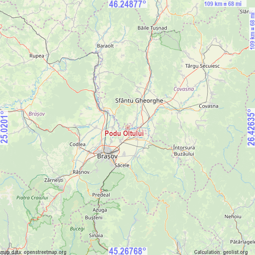
Podu Oltului GPS coordinates[2]
45° 45' 37.368" North, 25° 43' 23.592" East
| Map corner | latitude | longitude |
|---|---|---|
| Upper-left | 46.24877°, | 25.0201° |
| Center: | 45.76038°, | 25.72322° |
| Lower-right: | 45.26768°, | 26.42635° |
| Map W x H: | 109.1×109.1 km | = 67.8×67.8mi |
| max Lat: | 48.23793° ⇑50.7% North |
| Podu Oltului: | 45.76038° |
| min Lat: | ⇓49.3% South 43.65638° |
| min Long | Podu Oltului | max Long |
| 20.31667° | 25.72322° | 29.65403° |
| W 57.8%⇐ | ⇒42.2% E |
Elevation
Elevation of Podu Oltului is 498 m = 1634 ft, and this is 243.1 m = 798 ft above average elevation for this country.
| Max E: |
1278 m = 4193 ft | 10.9% |
| Podu Oltului | 498 m 1634 ft | |
| Avg. | 254.9 m = 836 ft | |
Min E: |
-2 m = -7 ft | 89.1% |
See also: Romania elevation on elevation.city.
Geographical zone
Podu Oltului is located in North temperate zone (between Tropic of Cancer and the Arctic Circle). Distance of this North polar circle is 2313.1 km =1437.3 mi to North.| Distance of | km | miles | from Podu Oltului |
|---|---|---|---|
| North Pole | 4919 | 3056.5 | to North |
| Arctic Circle | 2313.1 | 1437.3 | to North |
| Tropic Cancer | 2482.2 | 1542.4 | to South |
| Equator | 5088.1 | 3161.6 | to South |


Nearby cities:
15 places around Podu Oltului: (largest is in red/bold)
• Araci
7.8 km =4.8 mi,  317°
317°
• Bod
5.7 km =3.5 mi,  277°
277°
• Budila
12 km =7.5 mi,  150°
150°
• Chichiş
6.5 km =4 mi,  66°
66°
• Chilieni
10.6 km =6.6 mi,  36°
36°
• Colonia Bod
9.6 km =6 mi,  267°
267°
• Dobolii de Jos
3.6 km =2.2 mi,  47°
47°
• Feldioara
11.4 km =7.1 mi,  303°
303°
• Hărman
5.8 km =3.6 mi,  212°
212°
• Ilieni
5.5 km =3.4 mi, 37°
• Ozun
10.8 km =6.7 mi, 65°
• Prejmer
5.9 km =3.7 mi, 145°
• Sânpetru
8.7 km =5.4 mi,  230°
230°
• Tunelu-Teliu
11.9 km =7.4 mi,  124°
124°
• Vâlcele
10.4 km =6.5 mi,  342°
342°
Sources, notices
• [Note1] Compared only with cities in Romania existing in our database
• [Src1] Map data: © OpenStreetMap contributors (CC-BY-SA)
• [Src2] Other city data from geonames.org with taken over terms of usage.
• [Src3] Geographical zone / Annual Mean Temperature by Robert A. Rohde @ Wikipedia
