Glina geodata
Glina (Ilfov) is a seat of a second-order administrative division; located in Romania in Europe/Bucharest (GMT+3) time zone. With population of 7,227 people, there are 375 cities with bigger population in this country. Compared to other cities in Romania, 88.7% of cities are located further ↑North; 67.8% of cities are located further ←West and 88% of cities have higher elevation than Glina. Note1


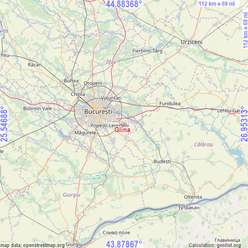
Glina GPS coordinates[2]
44° 22' 59.988" North, 26° 15' 0" East
| Map corner | latitude | longitude |
|---|---|---|
| Upper-left | 44.88368°, | 25.54688° |
| Center: | 44.38333°, | 26.25° |
| Lower-right: | 43.87867°, | 26.95313° |
| Map W x H: | 111.7×111.7 km | = 69.4×69.4mi |
| max Lat: | 48.23793° ⇑88.7% North |
| Glina: | 44.38333° |
| min Lat: | ⇓11.3% South 43.65638° |
| min Long | Glina | max Long |
| 20.31667° | 26.25° | 29.65403° |
| W 67.8%⇐ | ⇒32.2% E |
Elevation
Elevation of Glina is 67 m = 220 ft, and this is 187.9 m = 616 ft below average elevation for this country.
| Max E: |
1278 m = 4193 ft | 88% |
| Avg. | 254.9 m = 836 ft | |
| Glina | 67 m = 220 ft | |
Min E: |
-2 m = -7 ft | 12% |
See also: Romania elevation on elevation.city.
Geographical zone
Glina is located in North temperate zone (between Tropic of Cancer and the Arctic Circle). Distance of this Northern Tropic circle is 2329 km =1447.2 mi to South.| Distance of | km | miles | from Glina |
|---|---|---|---|
| North Pole | 5072.1 | 3151.7 | to North |
| Arctic Circle | 2466.2 | 1532.4 | to North |
| Tropic Cancer | 2329 | 1447.2 | to South |
| Equator | 4935 | 3066.5 | to South |


Nearby cities:
15 places around Glina: (largest is in red/bold)
• Berceni
9.2 km =5.7 mi,  213°
213°
• Brăneşti
9.9 km =6.2 mi,  41°
41°
• Bălăceanca
3.3 km =2.1 mi,  72°
72°
• Cernica
4.6 km =2.9 mi, 35°
• Căldăraru
3.5 km =2.2 mi,  17°
17°
• Cățelu
3.2 km =2 mi,  312°
312°
• Dobroeşti
9.1 km =5.7 mi,  324°
324°
• Fundeni
7.9 km =4.9 mi,  90°
90°
• Pantelimon
8.4 km =5.2 mi,  331°
331°
• Popeşti-Leordeni
6.6 km =4.1 mi,  270°
270°
• Postăvari
6.2 km =3.9 mi,  160°
160°
• Poșta
4.9 km =3 mi,  97°
97°
• Pădurișu
8.6 km =5.3 mi,  149°
149°
• Sector 3
7.8 km =4.8 mi,  304°
304°
• Tânganu
5.6 km =3.5 mi,  62°
62°
Sources, notices
• [Note1] Compared only with cities in Romania existing in our database
• [Src1] Map data: © OpenStreetMap contributors (CC-BY-SA)
• [Src2] Other city data from geonames.org with taken over terms of usage.
• [Src3] Geographical zone / Annual Mean Temperature by Robert A. Rohde @ Wikipedia
