Tânganu geodata
Tânganu (Ilfov) is a populated place; located in Romania in Europe/Bucharest (GMT+3) time zone. With population of 2,547 people, there are 2116 cities with bigger population in this country. Compared to other cities in Romania, 88% of cities are located further ↑North; 69.1% of cities are located further ←West and 90.2% of cities have higher elevation than Tânganu. Note1


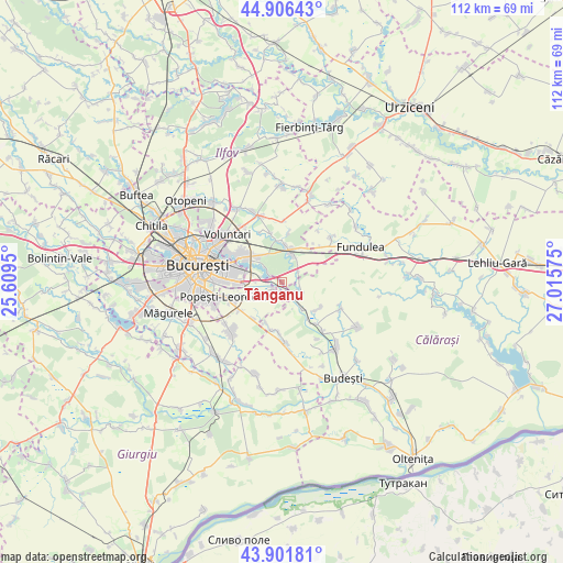
Tânganu GPS coordinates[2]
44° 24' 22.608" North, 26° 18' 45.432" East
| Map corner | latitude | longitude |
|---|---|---|
| Upper-left | 44.90643°, | 25.6095° |
| Center: | 44.40628°, | 26.31262° |
| Lower-right: | 43.90181°, | 27.01575° |
| Map W x H: | 111.7×111.7 km | = 69.4×69.4mi |
| max Lat: | 48.23793° ⇑88% North |
| Tânganu: | 44.40628° |
| min Lat: | ⇓12% South 43.65638° |
| min Long | Tânganu | max Long |
| 20.31667° | 26.31262° | 29.65403° |
| W 69.1%⇐ | ⇒30.9% E |
Elevation
Elevation of Tânganu is 57 m = 187 ft, and this is 197.9 m = 649 ft below average elevation for this country.
| Max E: |
1278 m = 4193 ft | 90.2% |
| Avg. | 254.9 m = 836 ft | |
| Tânganu | 57 m = 187 ft | |
Min E: |
-2 m = -7 ft | 9.8% |
See also: Romania elevation on elevation.city.
Geographical zone
Tânganu is located in North temperate zone (between Tropic of Cancer and the Arctic Circle). Distance of this Northern Tropic circle is 2331.6 km =1448.8 mi to South.| Distance of | km | miles | from Tânganu |
|---|---|---|---|
| North Pole | 5069.5 | 3150 | to North |
| Arctic Circle | 2463.7 | 1530.9 | to North |
| Tropic Cancer | 2331.6 | 1448.8 | to South |
| Equator | 4937.5 | 3068 | to South |


Nearby cities:
15 places around Tânganu: (largest is in red/bold)
• Brăneşti
5.1 km =3.2 mi,  18°
18°
• Bălăceanca
2.4 km =1.5 mi,  229°
229°
• Cernica
2.6 km =1.6 mi,  296°
296°
• Cozieni
8.1 km =5 mi,  355°
355°
• Căldăraru
4 km =2.5 mi,  280°
280°
• Cățelu
7.4 km =4.6 mi,  267°
267°
• Dorobanțu
8.6 km =5.3 mi,  132°
132°
• Fundeni
3.9 km =2.4 mi, 130°
• Glina
5.6 km =3.5 mi,  242°
242°
• Găneasa
8.9 km =5.5 mi,  344°
344°
• Islaz
8.5 km =5.3 mi,  44°
44°
• Pasărea
7.4 km =4.6 mi,  4°
4°
• Plătăreşti
7.6 km =4.7 mi,  145°
145°
• Postăvari
8.9 km =5.5 mi,  199°
199°
• Poșta
3.2 km =2 mi,  181°
181°
Sources, notices
• [Note1] Compared only with cities in Romania existing in our database
• [Src1] Map data: © OpenStreetMap contributors (CC-BY-SA)
• [Src2] Other city data from geonames.org with taken over terms of usage.
• [Src3] Geographical zone / Annual Mean Temperature by Robert A. Rohde @ Wikipedia
