Brăneşti geodata
Brăneşti (Ilfov) is a seat of a second-order administrative division; located in Romania in Europe/Bucharest (GMT+3) time zone. With population of 8,645 people, there are 270 cities with bigger population in this country. Compared to other cities in Romania, 86.8% of cities are located further ↑North; 69.5% of cities are located further ←West and 91.1% of cities have higher elevation than Brăneşti. Note1


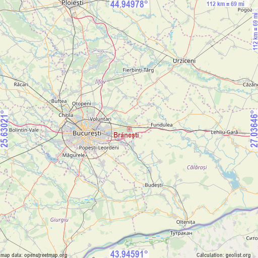
Brăneşti GPS coordinates[2]
44° 27' 0" North, 26° 19' 59.988" East
| Map corner | latitude | longitude |
|---|---|---|
| Upper-left | 44.94978°, | 25.63021° |
| Center: | 44.45°, | 26.33333° |
| Lower-right: | 43.94591°, | 27.03646° |
| Map W x H: | 111.6×111.6 km | = 69.3×69.3mi |
| max Lat: | 48.23793° ⇑86.8% North |
| Brăneşti: | 44.45° |
| min Lat: | ⇓13.2% South 43.65638° |
| min Long | Brăneşti | max Long |
| 20.31667° | 26.33333° | 29.65403° |
| W 69.5%⇐ | ⇒30.5% E |
Elevation
Elevation of Brăneşti is 53 m = 174 ft, and this is 201.9 m = 662 ft below average elevation for this country.
| Max E: |
1278 m = 4193 ft | 91.1% |
| Avg. | 254.9 m = 836 ft | |
| Brăneşti | 53 m = 174 ft | |
Min E: |
-2 m = -7 ft | 8.9% |
See also: Romania elevation on elevation.city.
Geographical zone
Brăneşti is located in North temperate zone (between Tropic of Cancer and the Arctic Circle). Distance of this Northern Tropic circle is 2336.5 km =1451.8 mi to South.| Distance of | km | miles | from Brăneşti |
|---|---|---|---|
| North Pole | 5064.7 | 3147.1 | to North |
| Arctic Circle | 2458.8 | 1527.8 | to North |
| Tropic Cancer | 2336.5 | 1451.8 | to South |
| Equator | 4942.4 | 3071.1 | to South |


Nearby cities:
15 places around Brăneşti: (largest is in red/bold)
• Afumaţi
9.1 km =5.7 mi,  324°
324°
• Belciugatele
8.8 km =5.5 mi,  64°
64°
• Bălăceanca
7.3 km =4.5 mi,  208°
208°
• Cernica
5.4 km =3.4 mi,  226°
226°
• Cozieni
4 km =2.5 mi, 324°
• Căldăraru
6.9 km =4.3 mi, 233°
• Fundeni
7.5 km =4.7 mi,  169°
169°
• Găneasa
5.4 km =3.4 mi,  313°
313°
• Islaz
4.5 km =2.8 mi,  73°
73°
• Moara Domnească
7.7 km =4.8 mi, 309°
• Pasărea
2.8 km =1.7 mi,  337°
337°
• Piteasca
4.8 km =3 mi,  357°
357°
• Poșta
8.2 km =5.1 mi,  192°
192°
• Tânganu
5.1 km =3.2 mi,  198°
198°
• Șindrilița
7.2 km =4.5 mi,  351°
351°
Sources, notices
• [Note1] Compared only with cities in Romania existing in our database
• [Src1] Map data: © OpenStreetMap contributors (CC-BY-SA)
• [Src2] Other city data from geonames.org with taken over terms of usage.
• [Src3] Geographical zone / Annual Mean Temperature by Robert A. Rohde @ Wikipedia
