Bălăceanca geodata
Bălăceanca (Ilfov) is a populated place; located in Romania in Europe/Bucharest (GMT+3) time zone. With population of 2,129 people, there are 2486 cities with bigger population in this country. Compared to other cities in Romania, 88.3% of cities are located further ↑North; 68.6% of cities are located further ←West and 88.2% of cities have higher elevation than Bălăceanca. Note1


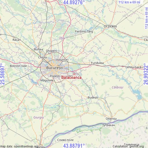
Bălăceanca GPS coordinates[2]
44° 23' 32.964" North, 26° 17' 24.324" East
| Map corner | latitude | longitude |
|---|---|---|
| Upper-left | 44.89276°, | 25.58697° |
| Center: | 44.39249°, | 26.29009° |
| Lower-right: | 43.88791°, | 26.99322° |
| Map W x H: | 111.7×111.7 km | = 69.4×69.4mi |
| max Lat: | 48.23793° ⇑88.3% North |
| Bălăceanca: | 44.39249° |
| min Lat: | ⇓11.7% South 43.65638° |
| min Long | Bălăceanca | max Long |
| 20.31667° | 26.29009° | 29.65403° |
| W 68.6%⇐ | ⇒31.4% E |
Elevation
Elevation of Bălăceanca is 66 m = 217 ft, and this is 188.9 m = 620 ft below average elevation for this country.
| Max E: |
1278 m = 4193 ft | 88.2% |
| Avg. | 254.9 m = 836 ft | |
| Bălăceanca | 66 m = 217 ft | |
Min E: |
-2 m = -7 ft | 11.8% |
See also: Romania elevation on elevation.city.
Geographical zone
Bălăceanca is located in North temperate zone (between Tropic of Cancer and the Arctic Circle). Distance of this Northern Tropic circle is 2330.1 km =1447.9 mi to South.| Distance of | km | miles | from Bălăceanca |
|---|---|---|---|
| North Pole | 5071.1 | 3151 | to North |
| Arctic Circle | 2465.2 | 1531.8 | to North |
| Tropic Cancer | 2330.1 | 1447.9 | to South |
| Equator | 4936 | 3067.1 | to South |


Nearby cities:
15 places around Bălăceanca: (largest is in red/bold)
• Brăneşti
7.3 km =4.5 mi,  28°
28°
• Cernica
2.7 km =1.7 mi,  348°
348°
• Căldăraru
3.1 km =1.9 mi,  316°
316°
• Cățelu
5.7 km =3.5 mi,  281°
281°
• Dorobanțu
9.3 km =5.8 mi,  117°
117°
• Fundeni
4.9 km =3 mi,  102°
102°
• Glina
3.3 km =2.1 mi,  252°
252°
• Pantelimon
9.6 km =6 mi,  311°
311°
• Pasărea
9.3 km =5.8 mi,  14°
14°
• Plătăreşti
7.7 km =4.8 mi,  127°
127°
• Podu Pitarului
9.1 km =5.7 mi, 129°
• Postăvari
7 km =4.3 mi,  189°
189°
• Poșta
2.4 km =1.5 mi, 133°
• Pădurișu
8.5 km =5.3 mi,  172°
172°
• Tânganu
2.4 km =1.5 mi,  49°
49°
Sources, notices
• [Note1] Compared only with cities in Romania existing in our database
• [Src1] Map data: © OpenStreetMap contributors (CC-BY-SA)
• [Src2] Other city data from geonames.org with taken over terms of usage.
• [Src3] Geographical zone / Annual Mean Temperature by Robert A. Rohde @ Wikipedia
