Ghioroiu geodata
Ghioroiu (Vâlcea) is a seat of a second-order administrative division; located in Romania in Europe/Bucharest (GMT+3) time zone. With population of 2,144 people, there are 2475 cities with bigger population in this country. Compared to other cities in Romania, 80.1% of cities are located further ↑North; 72.1% of cities are located further →East and 58% of cities have lower elevation than Ghioroiu. Note1


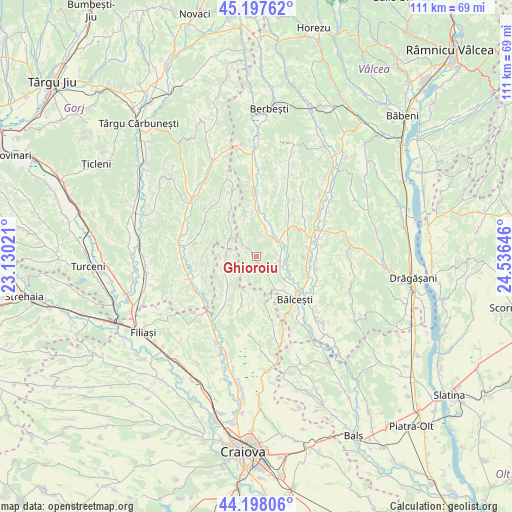
Ghioroiu GPS coordinates[2]
44° 42' 0" North, 23° 49' 59.988" East
| Map corner | latitude | longitude |
|---|---|---|
| Upper-left | 45.19762°, | 23.13021° |
| Center: | 44.7°, | 23.83333° |
| Lower-right: | 44.19806°, | 24.53646° |
| Map W x H: | 111.1×111.1 km | = 69×69mi |
| max Lat: | 48.23793° ⇑80.1% North |
| Ghioroiu: | 44.7° |
| min Lat: | ⇓19.9% South 43.65638° |
| min Long | Ghioroiu | max Long |
| 20.31667° | 23.83333° | 29.65403° |
| W 27.9%⇐ | ⇒72.1% E |
Elevation
Elevation of Ghioroiu is 253 m = 830 ft, and this is 1.9 m = 6 ft below average elevation for this country.
| Max E: |
1278 m = 4193 ft | 42% |
| Avg. | 254.9 m = 836 ft | |
| Ghioroiu | 253 m = 830 ft | |
Min E: |
-2 m = -7 ft | 58% |
See also: Romania elevation on elevation.city.
Geographical zone
Ghioroiu is located in North temperate zone (between Tropic of Cancer and the Arctic Circle). Distance of this Northern Tropic circle is 2364.3 km =1469.1 mi to South.| Distance of | km | miles | from Ghioroiu |
|---|---|---|---|
| North Pole | 5036.9 | 3129.8 | to North |
| Arctic Circle | 2431 | 1510.6 | to North |
| Tropic Cancer | 2364.3 | 1469.1 | to South |
| Equator | 4970.2 | 3088.3 | to South |


Nearby cities:
15 places around Ghioroiu: (largest is in red/bold)
• Benești
7.3 km =4.5 mi,  126°
126°
• Bălceşti
13.1 km =8.1 mi,  135°
135°
• Dănciuleşti
7.6 km =4.7 mi,  299°
299°
• Fărcaș
12.9 km =8 mi,  210°
210°
• Golumbu
9.7 km =6 mi,  220°
220°
• Lăcusteni
5.3 km =3.3 mi,  95°
95°
• Otetelișu
12.1 km =7.5 mi,  124°
124°
• Rădinești
11.5 km =7.1 mi,  331°
331°
• Slăvuța
11.8 km =7.3 mi,  269°
269°
• Sășcioara
11.6 km =7.2 mi,  14°
14°
• Tetoiu
8.6 km =5.3 mi,  49°
49°
• Tălpaș
7.2 km =4.5 mi,  254°
254°
• Velesti
11.6 km =7.2 mi,  197°
197°
• Zătreni
7.5 km =4.7 mi, 10°
• Țepești
12.5 km =7.8 mi,  34°
34°
Sources, notices
• [Note1] Compared only with cities in Romania existing in our database
• [Src1] Map data: © OpenStreetMap contributors (CC-BY-SA)
• [Src2] Other city data from geonames.org with taken over terms of usage.
• [Src3] Geographical zone / Annual Mean Temperature by Robert A. Rohde @ Wikipedia
