Sășcioara geodata
Sășcioara (Vâlcea) is a populated place; located in Romania in Europe/Bucharest (GMT+3) time zone. With population of 676 people, there are 5707 cities with bigger population in this country. Compared to other cities in Romania, 76.6% of cities are located further ↑North; 71.5% of cities are located further →East and 55.8% of cities have lower elevation than Sășcioara. Note1


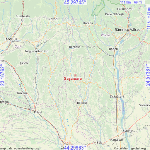
Sășcioara GPS coordinates[2]
44° 48' 2.52" North, 23° 52' 14.664" East
| Map corner | latitude | longitude |
|---|---|---|
| Upper-left | 45.29745°, | 23.16762° |
| Center: | 44.8007°, | 23.87074° |
| Lower-right: | 44.29963°, | 24.57387° |
| Map W x H: | 110.9×110.9 km | = 68.9×68.9mi |
| max Lat: | 48.23793° ⇑76.6% North |
| Sășcioara: | 44.8007° |
| min Lat: | ⇓23.4% South 43.65638° |
| min Long | Sășcioara | max Long |
| 20.31667° | 23.87074° | 29.65403° |
| W 28.5%⇐ | ⇒71.5% E |
Elevation
Elevation of Sășcioara is 242 m = 794 ft, and this is 12.9 m = 42 ft below average elevation for this country.
| Max E: |
1278 m = 4193 ft | 44.2% |
| Avg. | 254.9 m = 836 ft | |
| Sășcioara | 242 m = 794 ft | |
Min E: |
-2 m = -7 ft | 55.8% |
See also: Romania elevation on elevation.city.
Geographical zone
Sășcioara is located in North temperate zone (between Tropic of Cancer and the Arctic Circle). Distance of this Northern Tropic circle is 2375.5 km =1476.1 mi to South.| Distance of | km | miles | from Sășcioara |
|---|---|---|---|
| North Pole | 5025.7 | 3122.8 | to North |
| Arctic Circle | 2419.8 | 1503.6 | to North |
| Tropic Cancer | 2375.5 | 1476.1 | to South |
| Equator | 4981.4 | 3095.3 | to South |


Nearby cities:
15 places around Sășcioara: (largest is in red/bold)
• Dozești
7.2 km =4.5 mi,  94°
94°
• Dănciuleşti
12.1 km =7.5 mi,  231°
231°
• Fărtăţeşti
10.4 km =6.5 mi,  100°
100°
• Ghioroiu
11.6 km =7.2 mi,  194°
194°
• Grădiştea
8.5 km =5.3 mi,  329°
329°
• Livezi
5.7 km =3.5 mi,  320°
320°
• Lăcusteni
11.9 km =7.4 mi,  168°
168°
• Obârșia
8.4 km =5.2 mi,  282°
282°
• Piscoiu
10.8 km =6.7 mi,  301°
301°
• Românești
12.6 km =7.8 mi,  21°
21°
• Roşiile
8.8 km =5.5 mi,  33°
33°
• Rădinești
8.4 km =5.2 mi,  262°
262°
• Tetoiu
6.7 km =4.2 mi,  147°
147°
• Zătreni
4.1 km =2.5 mi,  203°
203°
• Țepești
4.2 km =2.6 mi, 102°
Sources, notices
• [Note1] Compared only with cities in Romania existing in our database
• [Src1] Map data: © OpenStreetMap contributors (CC-BY-SA)
• [Src2] Other city data from geonames.org with taken over terms of usage.
• [Src3] Geographical zone / Annual Mean Temperature by Robert A. Rohde @ Wikipedia
