Zătreni geodata
Zătreni (Vâlcea) is a seat of a second-order administrative division; located in Romania in Europe/Bucharest (GMT+3) time zone. With population of 4,524 people, there are 941 cities with bigger population in this country. Compared to other cities in Romania, 77.9% of cities are located further ↑North; 71.9% of cities are located further →East and 54.4% of cities have lower elevation than Zătreni. Note1


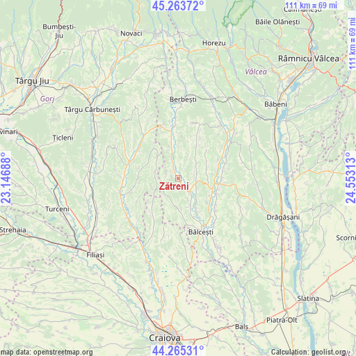
Zătreni GPS coordinates[2]
44° 46' 0.012" North, 23° 51' 0" East
| Map corner | latitude | longitude |
|---|---|---|
| Upper-left | 45.26372°, | 23.14688° |
| Center: | 44.76667°, | 23.85° |
| Lower-right: | 44.26531°, | 24.55313° |
| Map W x H: | 111×111 km | = 69×69mi |
| max Lat: | 48.23793° ⇑77.9% North |
| Zătreni: | 44.76667° |
| min Lat: | ⇓22.1% South 43.65638° |
| min Long | Zătreni | max Long |
| 20.31667° | 23.85° | 29.65403° |
| W 28.1%⇐ | ⇒71.9% E |
Elevation
Elevation of Zătreni is 235 m = 771 ft, and this is 19.9 m = 65 ft below average elevation for this country.
| Max E: |
1278 m = 4193 ft | 45.6% |
| Avg. | 254.9 m = 836 ft | |
| Zătreni | 235 m = 771 ft | |
Min E: |
-2 m = -7 ft | 54.4% |
See also: Romania elevation on elevation.city.
Geographical zone
Zătreni is located in North temperate zone (between Tropic of Cancer and the Arctic Circle). Distance of this Northern Tropic circle is 2371.7 km =1473.7 mi to South.| Distance of | km | miles | from Zătreni |
|---|---|---|---|
| North Pole | 5029.5 | 3125.2 | to North |
| Arctic Circle | 2423.6 | 1506 | to North |
| Tropic Cancer | 2371.7 | 1473.7 | to South |
| Equator | 4977.6 | 3092.9 | to South |


Nearby cities:
15 places around Zătreni: (largest is in red/bold)
• Benești
12.6 km =7.8 mi,  158°
158°
• Dozești
9.4 km =5.8 mi,  69°
69°
• Dănciuleşti
8.7 km =5.4 mi,  244°
244°
• Fărtăţeşti
12 km =7.5 mi,  81°
81°
• Ghioroiu
7.5 km =4.7 mi,  190°
190°
• Grădiştea
11.4 km =7.1 mi,  346°
346°
• Livezi
8.4 km =5.2 mi, 346°
• Lăcusteni
8.8 km =5.5 mi,  153°
153°
• Obârșia
8.6 km =5.3 mi,  310°
310°
• Piscoiu
12.2 km =7.6 mi,  321°
321°
• Rădinești
7.3 km =4.5 mi,  292°
292°
• Sășcioara
4.1 km =2.5 mi,  23°
23°
• Tetoiu
5.6 km =3.5 mi,  109°
109°
• Tălpaș
12.5 km =7.8 mi,  221°
221°
• Țepești
6.4 km =4 mi,  63°
63°
Sources, notices
• [Note1] Compared only with cities in Romania existing in our database
• [Src1] Map data: © OpenStreetMap contributors (CC-BY-SA)
• [Src2] Other city data from geonames.org with taken over terms of usage.
• [Src3] Geographical zone / Annual Mean Temperature by Robert A. Rohde @ Wikipedia
