Arpășel geodata
Arpășel (Bihor) is a populated place; located in Romania in Europe/Bucharest (GMT+3) time zone. With population of 905 people, there are 4605 cities with bigger population in this country. Compared to other cities in Romania, 72.6% of cities are located further ↓South; 96.4% of cities are located further →East and 78.7% of cities have higher elevation than Arpășel. Note1


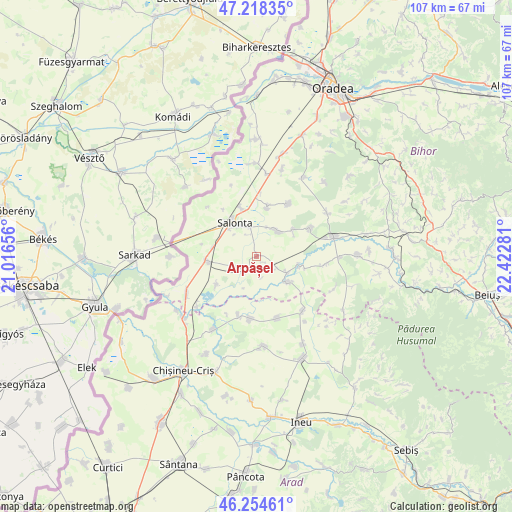
Arpășel GPS coordinates[2]
46° 44' 19.068" North, 21° 43' 10.848" East
| Map corner | latitude | longitude |
|---|---|---|
| Upper-left | 47.21835°, | 21.01656° |
| Center: | 46.73863°, | 21.71968° |
| Lower-right: | 46.25461°, | 22.42281° |
| Map W x H: | 107.2×107.2 km | = 66.6×66.6mi |
| max Lat: | 48.23793° ⇑27.4% North |
| Arpășel: | 46.73863° |
| min Lat: | ⇓72.6% South 43.65638° |
| min Long | Arpășel | max Long |
| 20.31667° | 21.71968° | 29.65403° |
| W 3.6%⇐ | ⇒96.4% E |
Elevation
Elevation of Arpășel is 99 m = 325 ft, and this is 155.9 m = 511 ft below average elevation for this country.
| Max E: |
1278 m = 4193 ft | 78.7% |
| Avg. | 254.9 m = 836 ft | |
| Arpășel | 99 m = 325 ft | |
Min E: |
-2 m = -7 ft | 21.3% |
See also: Romania elevation on elevation.city.
Geographical zone
Arpășel is located in North temperate zone (between Tropic of Cancer and the Arctic Circle). Distance of this North polar circle is 2204.3 km =1369.7 mi to North.| Distance of | km | miles | from Arpășel |
|---|---|---|---|
| North Pole | 4810.2 | 2988.9 | to North |
| Arctic Circle | 2204.3 | 1369.7 | to North |
| Tropic Cancer | 2590.9 | 1609.9 | to South |
| Equator | 5196.8 | 3229.1 | to South |


Nearby cities:
15 places around Arpășel: (largest is in red/bold)
• Batăr
8.6 km =5.3 mi,  120°
120°
• Boiu
10.2 km =6.3 mi,  234°
234°
• Ciumeghiu
10.4 km =6.5 mi,  266°
266°
• Căuașd
9.6 km =6 mi,  52°
52°
• Ghiorac
4 km =2.5 mi,  224°
224°
• Gurbediu
12.6 km =7.8 mi,  60°
60°
• Homorog
10.4 km =6.5 mi,  10°
10°
• Ianoșda
12.9 km =8 mi,  31°
31°
• Mădăraş
10.9 km =6.8 mi,  345°
345°
• Salonta
8.6 km =5.3 mi,  322°
322°
• Satu Nou
13 km =8.1 mi,  185°
185°
• Talpoș
8.3 km =5.2 mi,  129°
129°
• Tulca
6.9 km =4.3 mi,  44°
44°
• Tăut
9.3 km =5.8 mi,  102°
102°
• Vânători
13.2 km =8.2 mi,  195°
195°
Sources, notices
• [Note1] Compared only with cities in Romania existing in our database
• [Src1] Map data: © OpenStreetMap contributors (CC-BY-SA)
• [Src2] Other city data from geonames.org with taken over terms of usage.
• [Src3] Geographical zone / Annual Mean Temperature by Robert A. Rohde @ Wikipedia
