Salonta geodata
Salonta (Bihor) is a seat of a second-order administrative division; located in Romania in Europe/Bucharest (GMT+3) time zone. With population of 17,561 people, there are 115 cities with bigger population in this country. Compared to other cities in Romania, 74.1% of cities are located further ↓South; 96.8% of cities are located further →East and 80.8% of cities have higher elevation than Salonta. Note1


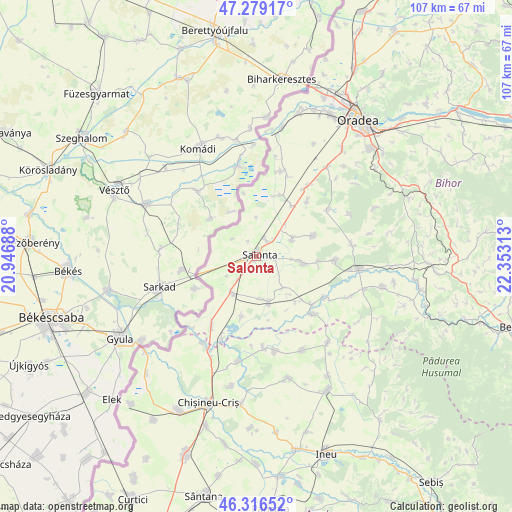
Salonta GPS coordinates[2]
46° 48' 0" North, 21° 39' 0" East
| Map corner | latitude | longitude |
|---|---|---|
| Upper-left | 47.27917°, | 20.94688° |
| Center: | 46.8°, | 21.65° |
| Lower-right: | 46.31652°, | 22.35313° |
| Map W x H: | 107×107 km | = 66.5×66.5mi |
| max Lat: | 48.23793° ⇑25.9% North |
| Salonta: | 46.8° |
| min Lat: | ⇓74.1% South 43.65638° |
| min Long | Salonta | max Long |
| 20.31667° | 21.65° | 29.65403° |
| W 3.2%⇐ | ⇒96.8% E |
Elevation
Elevation of Salonta is 92 m = 302 ft, and this is 162.9 m = 534 ft below average elevation for this country.
| Max E: |
1278 m = 4193 ft | 80.8% |
| Avg. | 254.9 m = 836 ft | |
| Salonta | 92 m = 302 ft | |
Min E: |
-2 m = -7 ft | 19.2% |
See also: Romania elevation on elevation.city.
Geographical zone
Salonta is located in North temperate zone (between Tropic of Cancer and the Arctic Circle). Distance of this North polar circle is 2197.5 km =1365.5 mi to North.| Distance of | km | miles | from Salonta |
|---|---|---|---|
| North Pole | 4803.4 | 2984.7 | to North |
| Arctic Circle | 2197.5 | 1365.5 | to North |
| Tropic Cancer | 2597.8 | 1614.2 | to South |
| Equator | 5203.7 | 3233.4 | to South |


Nearby cities:
15 places around Salonta: (largest is in red/bold)
• Arpășel
8.6 km =5.3 mi,  142°
142°
• Bicaci
15.4 km =9.6 mi,  42°
42°
• Boiu
13 km =8.1 mi,  193°
193°
• Cefa
14.4 km =8.9 mi,  26°
26°
• Ciumeghiu
9 km =5.6 mi,  214°
214°
• Căuașd
13 km =8.1 mi,  94°
94°
• Ghiorac
10 km =6.2 mi,  165°
165°
• Gurbediu
16.4 km =10.2 mi, 92°
• Homorog
8 km =5 mi,  64°
64°
• Ianoșda
12.7 km =7.9 mi,  70°
70°
• Inand
13 km =8.1 mi, 36°
• Mădăraş
4.5 km =2.8 mi, 34°
• Talpoș
16.8 km =10.4 mi, 135°
• Tulca
10.3 km =6.4 mi,  100°
100°
• Tăut
16.9 km =10.5 mi,  121°
121°
Sources, notices
• [Note1] Compared only with cities in Romania existing in our database
• [Src1] Map data: © OpenStreetMap contributors (CC-BY-SA)
• [Src2] Other city data from geonames.org with taken over terms of usage.
• [Src3] Geographical zone / Annual Mean Temperature by Robert A. Rohde @ Wikipedia
