Gătaia geodata
Gătaia (Timiş) is a seat of a second-order administrative division; located in Romania in Europe/Bucharest (GMT+3) time zone. With population of 8,002 people, there are 313 cities with bigger population in this country. Compared to other cities in Romania, 56.5% of cities are located further ↑North; 97.9% of cities are located further →East and 75.4% of cities have higher elevation than Gătaia. Note1


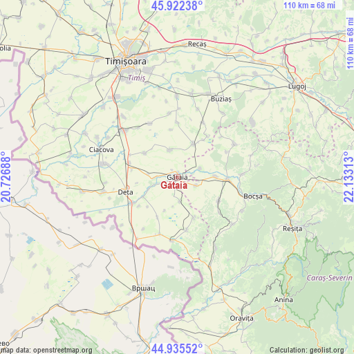
Gătaia GPS coordinates[2]
45° 25' 51.996" North, 21° 25' 48" East
| Map corner | latitude | longitude |
|---|---|---|
| Upper-left | 45.92238°, | 20.72688° |
| Center: | 45.43111°, | 21.43° |
| Lower-right: | 44.93552°, | 22.13313° |
| Map W x H: | 109.7×109.7 km | = 68.2×68.2mi |
| max Lat: | 48.23793° ⇑56.5% North |
| Gătaia: | 45.43111° |
| min Lat: | ⇓43.5% South 43.65638° |
| min Long | Gătaia | max Long |
| 20.31667° | 21.43° | 29.65403° |
| W 2.1%⇐ | ⇒97.9% E |
Elevation
Elevation of Gătaia is 109 m = 358 ft, and this is 145.9 m = 479 ft below average elevation for this country.
| Max E: |
1278 m = 4193 ft | 75.4% |
| Avg. | 254.9 m = 836 ft | |
| Gătaia | 109 m = 358 ft | |
Min E: |
-2 m = -7 ft | 24.6% |
See also: Romania elevation on elevation.city.
Geographical zone
Gătaia is located in North temperate zone (between Tropic of Cancer and the Arctic Circle). Distance of this North polar circle is 2349.7 km =1460 mi to North.| Distance of | km | miles | from Gătaia |
|---|---|---|---|
| North Pole | 4955.6 | 3079.3 | to North |
| Arctic Circle | 2349.7 | 1460 | to North |
| Tropic Cancer | 2445.5 | 1519.6 | to South |
| Equator | 5051.5 | 3138.9 | to South |


Nearby cities:
15 places around Gătaia: (largest is in red/bold)
• Berzovia
15.5 km =9.6 mi,  92°
92°
• Birda
6.7 km =4.2 mi,  268°
268°
• Breștea
14.9 km =9.3 mi,  233°
233°
• Denta
16.5 km =10.3 mi,  238°
238°
• Ferendia
13.8 km =8.6 mi,  157°
157°
• Fizeș
14.9 km =9.3 mi,  120°
120°
• Gherteniș
11.8 km =7.3 mi, 88°
• Măureni
6.4 km =4 mi, 118°
• Opatița
12.7 km =7.9 mi,  261°
261°
• Sculia
1.5 km =0.9 mi,  6°
6°
• Sângeorge
9.3 km =5.8 mi,  247°
247°
• Tormac
11.1 km =6.9 mi,  26°
26°
• Voiteg
15.5 km =9.6 mi,  285°
285°
• Șipet
8.8 km =5.5 mi,  344°
344°
• Șoșdea
7.7 km =4.8 mi,  69°
69°
Sources, notices
• [Note1] Compared only with cities in Romania existing in our database
• [Src1] Map data: © OpenStreetMap contributors (CC-BY-SA)
• [Src2] Other city data from geonames.org with taken over terms of usage.
• [Src3] Geographical zone / Annual Mean Temperature by Robert A. Rohde @ Wikipedia
