Opatița geodata
Opatița (Timiş) is a populated place; located in Romania in Europe/Bucharest (GMT+3) time zone. With population of 632 people, there are 5994 cities with bigger population in this country. Compared to other cities in Romania, 56.7% of cities are located further ↑North; 98.5% of cities are located further →East and 79% of cities have higher elevation than Opatița. Note1


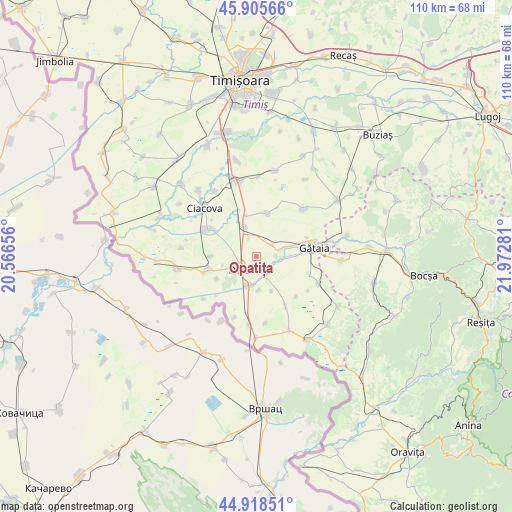
Opatița GPS coordinates[2]
45° 24' 51.264" North, 21° 16' 10.848" East
| Map corner | latitude | longitude |
|---|---|---|
| Upper-left | 45.90566°, | 20.56656° |
| Center: | 45.41424°, | 21.26968° |
| Lower-right: | 44.91851°, | 21.97281° |
| Map W x H: | 109.8×109.8 km | = 68.2×68.2mi |
| max Lat: | 48.23793° ⇑56.7% North |
| Opatița: | 45.41424° |
| min Lat: | ⇓43.3% South 43.65638° |
| min Long | Opatița | max Long |
| 20.31667° | 21.26968° | 29.65403° |
| W 1.5%⇐ | ⇒98.5% E |
Elevation
Elevation of Opatița is 98 m = 322 ft, and this is 156.9 m = 515 ft below average elevation for this country.
| Max E: |
1278 m = 4193 ft | 79% |
| Avg. | 254.9 m = 836 ft | |
| Opatița | 98 m = 322 ft | |
Min E: |
-2 m = -7 ft | 21% |
See also: Romania elevation on elevation.city.
Geographical zone
Opatița is located in North temperate zone (between Tropic of Cancer and the Arctic Circle). Distance of this North polar circle is 2351.6 km =1461.2 mi to North.| Distance of | km | miles | from Opatița |
|---|---|---|---|
| North Pole | 4957.5 | 3080.4 | to North |
| Arctic Circle | 2351.6 | 1461.2 | to North |
| Tropic Cancer | 2443.7 | 1518.4 | to South |
| Equator | 5049.6 | 3137.7 | to South |


Nearby cities:
15 places around Opatița: (largest is in red/bold)
• Banloc
10.9 km =6.8 mi,  254°
254°
• Birda
6 km =3.7 mi,  73°
73°
• Breștea
6.9 km =4.3 mi,  175°
175°
• Ciacova
15.2 km =9.4 mi,  313°
313°
• Denta
6.9 km =4.3 mi,  193°
193°
• Deta
4.5 km =2.8 mi,  231°
231°
• Dolaț
16 km =9.9 mi,  276°
276°
• Ghilad
11.7 km =7.3 mi,  298°
298°
• Gătaia
12.7 km =7.9 mi,  81°
81°
• Sculia
13.1 km =8.1 mi, 75°
• Soca
9.5 km =5.9 mi,  239°
239°
• Stamora Germană
14.8 km =9.2 mi, 185°
• Sângeorge
4.2 km =2.6 mi,  112°
112°
• Voiteg
6.5 km =4 mi,  338°
338°
• Șipet
14.5 km =9 mi,  44°
44°
Sources, notices
• [Note1] Compared only with cities in Romania existing in our database
• [Src1] Map data: © OpenStreetMap contributors (CC-BY-SA)
• [Src2] Other city data from geonames.org with taken over terms of usage.
• [Src3] Geographical zone / Annual Mean Temperature by Robert A. Rohde @ Wikipedia
