Breștea geodata
Breștea (Timiş) is a populated place; located in Romania in Europe/Bucharest (GMT+3) time zone. With population of 589 people, there are 6291 cities with bigger population in this country. Compared to other cities in Romania, 57.8% of cities are located further ↑North; 98.5% of cities are located further →East and 79.9% of cities have higher elevation than Breștea. Note1


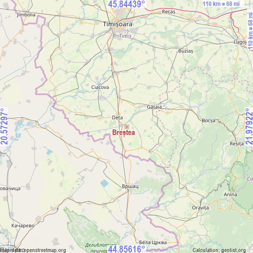
Breștea GPS coordinates[2]
45° 21' 8.748" North, 21° 16' 33.924" East
| Map corner | latitude | longitude |
|---|---|---|
| Upper-left | 45.84439°, | 20.57297° |
| Center: | 45.35243°, | 21.27609° |
| Lower-right: | 44.85616°, | 21.97922° |
| Map W x H: | 109.9×109.9 km | = 68.3×68.3mi |
| max Lat: | 48.23793° ⇑57.8% North |
| Breștea: | 45.35243° |
| min Lat: | ⇓42.2% South 43.65638° |
| min Long | Breștea | max Long |
| 20.31667° | 21.27609° | 29.65403° |
| W 1.5%⇐ | ⇒98.5% E |
Elevation
Elevation of Breștea is 95 m = 312 ft, and this is 159.9 m = 525 ft below average elevation for this country.
| Max E: |
1278 m = 4193 ft | 79.9% |
| Avg. | 254.9 m = 836 ft | |
| Breștea | 95 m = 312 ft | |
Min E: |
-2 m = -7 ft | 20.1% |
See also: Romania elevation on elevation.city.
Geographical zone
Breștea is located in North temperate zone (between Tropic of Cancer and the Arctic Circle). Distance of this North polar circle is 2358.5 km =1465.5 mi to North.| Distance of | km | miles | from Breștea |
|---|---|---|---|
| North Pole | 4964.3 | 3084.7 | to North |
| Arctic Circle | 2358.5 | 1465.5 | to North |
| Tropic Cancer | 2436.8 | 1514.2 | to South |
| Equator | 5042.7 | 3133.4 | to South |


Nearby cities:
15 places around Breștea: (largest is in red/bold)
• Banloc
11.6 km =7.2 mi,  289°
289°
• Birda
10.1 km =6.3 mi,  31°
31°
• Clopodia
16.8 km =10.4 mi,  117°
117°
• Denta
2.1 km =1.3 mi,  274°
274°
• Deta
5.7 km =3.5 mi,  315°
315°
• Ghilad
16.5 km =10.3 mi, 319°
• Gătaia
14.9 km =9.3 mi,  53°
53°
• Jamu Mare
15.5 km =9.6 mi,  134°
134°
• Moraviţa
10.8 km =6.7 mi,  182°
182°
• Opatița
6.9 km =4.3 mi,  355°
355°
• Sculia
15.9 km =9.9 mi, 50°
• Soca
9 km =5.6 mi,  283°
283°
• Stamora Germană
8.1 km =5 mi,  193°
193°
• Sângeorge
6.2 km =3.9 mi, 32°
• Voiteg
13.3 km =8.3 mi,  347°
347°
Sources, notices
• [Note1] Compared only with cities in Romania existing in our database
• [Src1] Map data: © OpenStreetMap contributors (CC-BY-SA)
• [Src2] Other city data from geonames.org with taken over terms of usage.
• [Src3] Geographical zone / Annual Mean Temperature by Robert A. Rohde @ Wikipedia
