Voiteg geodata
Voiteg (Timiş) is a seat of a second-order administrative division; located in Romania in Europe/Bucharest (GMT+3) time zone. With population of 2,402 people, there are 2235 cities with bigger population in this country. Compared to other cities in Romania, 55.9% of cities are located further ↑North; 98.6% of cities are located further →East and 83.1% of cities have higher elevation than Voiteg. Note1


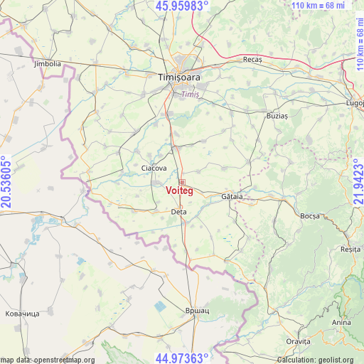
Voiteg GPS coordinates[2]
45° 28' 8.004" North, 21° 14' 21.012" East
| Map corner | latitude | longitude |
|---|---|---|
| Upper-left | 45.95983°, | 20.53605° |
| Center: | 45.46889°, | 21.23917° |
| Lower-right: | 44.97363°, | 21.9423° |
| Map W x H: | 109.7×109.7 km | = 68.2×68.2mi |
| max Lat: | 48.23793° ⇑55.9% North |
| Voiteg: | 45.46889° |
| min Lat: | ⇓44.1% South 43.65638° |
| min Long | Voiteg | max Long |
| 20.31667° | 21.23917° | 29.65403° |
| W 1.4%⇐ | ⇒98.6% E |
Elevation
Elevation of Voiteg is 84 m = 276 ft, and this is 170.9 m = 561 ft below average elevation for this country.
| Max E: |
1278 m = 4193 ft | 83.1% |
| Avg. | 254.9 m = 836 ft | |
| Voiteg | 84 m = 276 ft | |
Min E: |
-2 m = -7 ft | 16.9% |
See also: Romania elevation on elevation.city.
Geographical zone
Voiteg is located in North temperate zone (between Tropic of Cancer and the Arctic Circle). Distance of this North polar circle is 2345.5 km =1457.4 mi to North.| Distance of | km | miles | from Voiteg |
|---|---|---|---|
| North Pole | 4951.4 | 3076.7 | to North |
| Arctic Circle | 2345.5 | 1457.4 | to North |
| Tropic Cancer | 2449.7 | 1522.2 | to South |
| Equator | 5055.7 | 3141.5 | to South |


Nearby cities:
15 places around Voiteg: (largest is in red/bold)
• Banloc
12.1 km =7.5 mi,  221°
221°
• Birda
9.2 km =5.7 mi,  117°
117°
• Breștea
13.3 km =8.3 mi,  167°
167°
• Ciacova
9.7 km =6 mi,  296°
296°
• Denta
12.8 km =8 mi,  176°
176°
• Deta
9 km =5.6 mi,  187°
187°
• Ghilad
7.9 km =4.9 mi,  266°
266°
• Jebel
9.8 km =6.1 mi,  348°
348°
• Liebling
13.7 km =8.5 mi,  28°
28°
• Obad
10.2 km =6.3 mi,  321°
321°
• Opatița
6.5 km =4 mi,  158°
158°
• Petroman
12.7 km =7.9 mi,  309°
309°
• Soca
12.3 km =7.6 mi,  208°
208°
• Sângeorge
9.9 km =6.2 mi,  140°
140°
• Șipet
13.3 km =8.3 mi,  71°
71°
Sources, notices
• [Note1] Compared only with cities in Romania existing in our database
• [Src1] Map data: © OpenStreetMap contributors (CC-BY-SA)
• [Src2] Other city data from geonames.org with taken over terms of usage.
• [Src3] Geographical zone / Annual Mean Temperature by Robert A. Rohde @ Wikipedia
