Găinești geodata
Găinești (Suceava) is a populated place; located in Romania in Europe/Bucharest (GMT+3) time zone. With population of 2,000 people, there are 2596 cities with bigger population in this country. Compared to other cities in Romania, 89.3% of cities are located further ↓South; 61.4% of cities are located further ←West and 92.1% of cities have lower elevation than Găinești. Note1


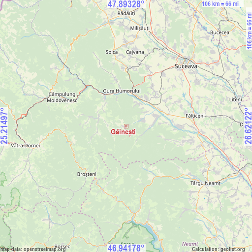
Găinești GPS coordinates[2]
47° 25' 10.848" North, 25° 55' 5.124" East
| Map corner | latitude | longitude |
|---|---|---|
| Upper-left | 47.89328°, | 25.21497° |
| Center: | 47.41968°, | 25.91809° |
| Lower-right: | 46.94178°, | 26.62122° |
| Map W x H: | 105.8×105.8 km | = 65.7×65.7mi |
| max Lat: | 48.23793° ⇑10.7% North |
| Găinești: | 47.41968° |
| min Lat: | ⇓89.3% South 43.65638° |
| min Long | Găinești | max Long |
| 20.31667° | 25.91809° | 29.65403° |
| W 61.4%⇐ | ⇒38.6% E |
Elevation
Elevation of Găinești is 550 m = 1804 ft, and this is 295.1 m = 968 ft above average elevation for this country.
| Max E: |
1278 m = 4193 ft | 7.9% |
| Găinești | 550 m 1804 ft | |
| Avg. | 254.9 m = 836 ft | |
Min E: |
-2 m = -7 ft | 92.1% |
See also: Romania elevation on elevation.city.
Geographical zone
Găinești is located in North temperate zone (between Tropic of Cancer and the Arctic Circle). Distance of this North polar circle is 2128.6 km =1322.7 mi to North.| Distance of | km | miles | from Găinești |
|---|---|---|---|
| North Pole | 4734.5 | 2941.9 | to North |
| Arctic Circle | 2128.6 | 1322.7 | to North |
| Tropic Cancer | 2666.7 | 1657 | to South |
| Equator | 5272.6 | 3276.2 | to South |


Nearby cities:
15 places around Găinești: (largest is in red/bold)
• Capu Codrului
13.4 km =8.3 mi,  22°
22°
• Capu Câmpului
10.9 km =6.8 mi,  25°
25°
• Doroteia
12.7 km =7.9 mi,  314°
314°
• Herla
7.6 km =4.7 mi,  70°
70°
• Mironu
10.2 km =6.3 mi,  42°
42°
• Mălini
13.5 km =8.4 mi, 67°
• Negrileasa
7.7 km =4.8 mi,  273°
273°
• Ostra
11.6 km =7.2 mi,  259°
259°
• Plutonița
11.7 km =7.3 mi, 305°
• Poiana Mărului
9.3 km =5.8 mi,  95°
95°
• Pâraie
12.1 km =7.5 mi, 66°
• Slatina
8.1 km =5 mi, 65°
• Stulpicani
12.5 km =7.8 mi,  294°
294°
• Vadu Negrilesei
7 km =4.3 mi,  236°
236°
• Valea Moldovei
10.1 km =6.3 mi,  58°
58°
Sources, notices
• [Note1] Compared only with cities in Romania existing in our database
• [Src1] Map data: © OpenStreetMap contributors (CC-BY-SA)
• [Src2] Other city data from geonames.org with taken over terms of usage.
• [Src3] Geographical zone / Annual Mean Temperature by Robert A. Rohde @ Wikipedia
