Frunzeni geodata
Frunzeni (Mureş) is a populated place; located in Romania in Europe/Bucharest (GMT+3) time zone. With population of 532 people, there are 6760 cities with bigger population in this country. Compared to other cities in Romania, 74.4% of cities are located further ↓South; 59.2% of cities are located further →East and 80.4% of cities have lower elevation than Frunzeni. Note1


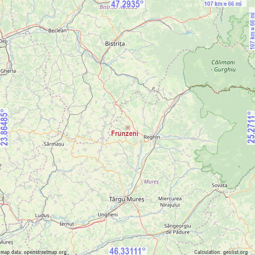
Frunzeni GPS coordinates[2]
46° 48' 52.056" North, 24° 34' 4.692" East
| Map corner | latitude | longitude |
|---|---|---|
| Upper-left | 47.2935°, | 23.86485° |
| Center: | 46.81446°, | 24.56797° |
| Lower-right: | 46.33111°, | 25.2711° |
| Map W x H: | 107×107 km | = 66.5×66.5mi |
| max Lat: | 48.23793° ⇑25.6% North |
| Frunzeni: | 46.81446° |
| min Lat: | ⇓74.4% South 43.65638° |
| min Long | Frunzeni | max Long |
| 20.31667° | 24.56797° | 29.65403° |
| W 40.8%⇐ | ⇒59.2% E |
Elevation
Elevation of Frunzeni is 397 m = 1302 ft, and this is 142.1 m = 466 ft above average elevation for this country.
| Max E: |
1278 m = 4193 ft | 19.6% |
| Frunzeni | 397 m 1302 ft | |
| Avg. | 254.9 m = 836 ft | |
Min E: |
-2 m = -7 ft | 80.4% |
See also: Romania elevation on elevation.city.
Geographical zone
Frunzeni is located in North temperate zone (between Tropic of Cancer and the Arctic Circle). Distance of this North polar circle is 2195.9 km =1364.5 mi to North.| Distance of | km | miles | from Frunzeni |
|---|---|---|---|
| North Pole | 4801.8 | 2983.7 | to North |
| Arctic Circle | 2195.9 | 1364.5 | to North |
| Tropic Cancer | 2599.4 | 1615.2 | to South |
| Equator | 5205.3 | 3234.4 | to South |


Nearby cities:
15 places around Frunzeni: (largest is in red/bold)
• Batoş
10.7 km =6.6 mi,  44°
44°
• Breaza
7.3 km =4.5 mi,  136°
136°
• Băița
3.8 km =2.4 mi,  310°
310°
• Cozma
2.6 km =1.6 mi,  275°
275°
• Dedrad
7 km =4.3 mi,  79°
79°
• Filpișu Mare
6.9 km =4.3 mi,  166°
166°
• Fărăgău
6.6 km =4.1 mi,  216°
216°
• Goreni
8 km =5 mi,  56°
56°
• Logig
7.2 km =4.5 mi,  3°
3°
• Lunca
4 km =2.5 mi,  358°
358°
• Milaş
10.2 km =6.3 mi,  271°
271°
• Ocnița
8.2 km =5.1 mi, 310°
• Reghin
11.2 km =7 mi,  113°
113°
• Reghin-Sat
11.8 km =7.3 mi, 107°
• Tonciu
4 km =2.5 mi,  197°
197°
Sources, notices
• [Note1] Compared only with cities in Romania existing in our database
• [Src1] Map data: © OpenStreetMap contributors (CC-BY-SA)
• [Src2] Other city data from geonames.org with taken over terms of usage.
• [Src3] Geographical zone / Annual Mean Temperature by Robert A. Rohde @ Wikipedia
