Dedrad geodata
Dedrad (Mureş) is a populated place; located in Romania in Europe/Bucharest (GMT+3) time zone. With population of 1,424 people, there are 3301 cities with bigger population in this country. Compared to other cities in Romania, 74.7% of cities are located further ↓South; 57.9% of cities are located further →East and 81.2% of cities have lower elevation than Dedrad. Note1


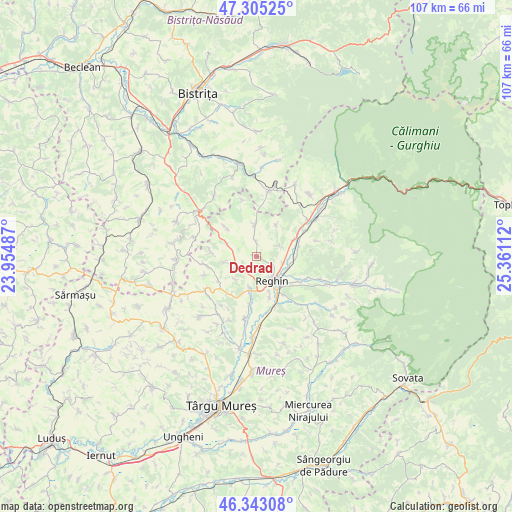
Dedrad GPS coordinates[2]
46° 49' 34.752" North, 24° 39' 28.764" East
| Map corner | latitude | longitude |
|---|---|---|
| Upper-left | 47.30525°, | 23.95487° |
| Center: | 46.82632°, | 24.65799° |
| Lower-right: | 46.34308°, | 25.36112° |
| Map W x H: | 107×107 km | = 66.5×66.5mi |
| max Lat: | 48.23793° ⇑25.3% North |
| Dedrad: | 46.82632° |
| min Lat: | ⇓74.7% South 43.65638° |
| min Long | Dedrad | max Long |
| 20.31667° | 24.65799° | 29.65403° |
| W 42.1%⇐ | ⇒57.9% E |
Elevation
Elevation of Dedrad is 404 m = 1325 ft, and this is 149.1 m = 489 ft above average elevation for this country.
| Max E: |
1278 m = 4193 ft | 18.8% |
| Dedrad | 404 m 1325 ft | |
| Avg. | 254.9 m = 836 ft | |
Min E: |
-2 m = -7 ft | 81.2% |
See also: Romania elevation on elevation.city.
Geographical zone
Dedrad is located in North temperate zone (between Tropic of Cancer and the Arctic Circle). Distance of this North polar circle is 2194.6 km =1363.7 mi to North.| Distance of | km | miles | from Dedrad |
|---|---|---|---|
| North Pole | 4800.5 | 2982.9 | to North |
| Arctic Circle | 2194.6 | 1363.7 | to North |
| Tropic Cancer | 2600.7 | 1616 | to South |
| Equator | 5206.6 | 3235.2 | to South |


Nearby cities:
15 places around Dedrad: (largest is in red/bold)
• Apalina
8.7 km =5.4 mi,  161°
161°
• Batoş
6.4 km =4 mi,  5°
5°
• Breaza
6.9 km =4.3 mi,  195°
195°
• Brâncoveneşti
8.4 km =5.2 mi,  66°
66°
• Cozma
9.5 km =5.9 mi,  263°
263°
• Frunzeni
7 km =4.3 mi, 259°
• Goreni
3.2 km =2 mi,  356°
356°
• Ideciu de Jos
7.6 km =4.7 mi,  112°
112°
• Iernuțeni
8.4 km =5.2 mi,  146°
146°
• Logig
8.7 km =5.4 mi,  312°
312°
• Luieriu
5.2 km =3.2 mi,  59°
59°
• Lunca
7.4 km =4.6 mi,  290°
290°
• Reghin
6.7 km =4.2 mi, 149°
• Reghin-Sat
6.5 km =4 mi,  136°
136°
• Suseni
5.8 km =3.6 mi,  103°
103°
Sources, notices
• [Note1] Compared only with cities in Romania existing in our database
• [Src1] Map data: © OpenStreetMap contributors (CC-BY-SA)
• [Src2] Other city data from geonames.org with taken over terms of usage.
• [Src3] Geographical zone / Annual Mean Temperature by Robert A. Rohde @ Wikipedia
