Fântânele geodata
Fântânele (Mureş) is a seat of a second-order administrative division; located in Romania in Europe/Bucharest (GMT+3) time zone. With population of 4,981 people, there are 792 cities with bigger population in this country. Compared to other cities in Romania, 65% of cities are located further ↓South; 56.4% of cities are located further →East and 71.4% of cities have lower elevation than Fântânele. Note1


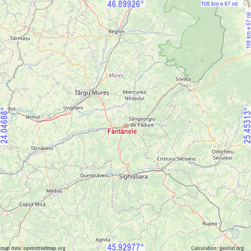
Fântânele GPS coordinates[2]
46° 25' 0.012" North, 24° 45' 0" East
| Map corner | latitude | longitude |
|---|---|---|
| Upper-left | 46.89926°, | 24.04688° |
| Center: | 46.41667°, | 24.75° |
| Lower-right: | 45.92977°, | 25.45313° |
| Map W x H: | 107.8×107.8 km | = 67×67mi |
| max Lat: | 48.23793° ⇑35% North |
| Fântânele: | 46.41667° |
| min Lat: | ⇓65% South 43.65638° |
| min Long | Fântânele | max Long |
| 20.31667° | 24.75° | 29.65403° |
| W 43.6%⇐ | ⇒56.4% E |
Elevation
Elevation of Fântânele is 330 m = 1083 ft, and this is 75.1 m = 246 ft above average elevation for this country.
| Max E: |
1278 m = 4193 ft | 28.6% |
| Fântânele | 330 m 1083 ft | |
| Avg. | 254.9 m = 836 ft | |
Min E: |
-2 m = -7 ft | 71.4% |
See also: Romania elevation on elevation.city.
Geographical zone
Fântânele is located in North temperate zone (between Tropic of Cancer and the Arctic Circle). Distance of this North polar circle is 2240.1 km =1391.9 mi to North.| Distance of | km | miles | from Fântânele |
|---|---|---|---|
| North Pole | 4846 | 3011.2 | to North |
| Arctic Circle | 2240.1 | 1391.9 | to North |
| Tropic Cancer | 2555.1 | 1587.7 | to South |
| Equator | 5161 | 3206.9 | to South |


Nearby cities:
15 places around Fântânele: (largest is in red/bold)
• Acăţari
11.4 km =7.1 mi,  308°
308°
• Agrișteu
5.7 km =3.5 mi,  241°
241°
• Bălăuşeri
5.4 km =3.4 mi,  250°
250°
• Chendu
3.1 km =1.9 mi,  210°
210°
• Călimănești
1.3 km =0.8 mi, 254°
• Dumitreni
1.9 km =1.2 mi,  159°
159°
• Găleşti
11.1 km =6.9 mi,  0°
0°
• Nadeş
11.2 km =7 mi,  186°
186°
• Neaua
9.8 km =6.1 mi,  40°
40°
• Păsăreni
8.3 km =5.2 mi,  332°
332°
• Sângeorgiu de Pădure
7.3 km =4.5 mi,  77°
77°
• Troița
7.7 km =4.8 mi,  11°
11°
• Veţca
7.8 km =4.8 mi, 160°
• Viforoasa
4.9 km =3 mi,  69°
69°
• Țigmandru
7.3 km =4.5 mi,  199°
199°
Sources, notices
• [Note1] Compared only with cities in Romania existing in our database
• [Src1] Map data: © OpenStreetMap contributors (CC-BY-SA)
• [Src2] Other city data from geonames.org with taken over terms of usage.
• [Src3] Geographical zone / Annual Mean Temperature by Robert A. Rohde @ Wikipedia
