Țigmandru geodata
Țigmandru (Mureş) is a populated place; located in Romania in Europe/Bucharest (GMT+3) time zone. With population of 859 people, there are 4794 cities with bigger population in this country. Compared to other cities in Romania, 63.6% of cities are located further ↓South; 56.8% of cities are located further →East and 74.6% of cities have lower elevation than Țigmandru. Note1


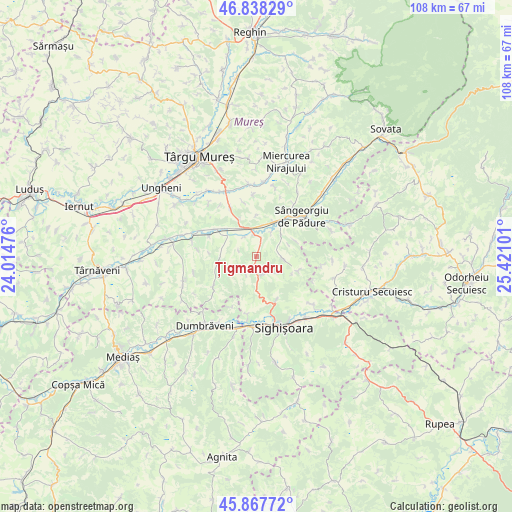
Țigmandru GPS coordinates[2]
46° 21' 18.576" North, 24° 43' 4.368" East
| Map corner | latitude | longitude |
|---|---|---|
| Upper-left | 46.83829°, | 24.01476° |
| Center: | 46.35516°, | 24.71788° |
| Lower-right: | 45.86772°, | 25.42101° |
| Map W x H: | 107.9×107.9 km | = 67×67mi |
| max Lat: | 48.23793° ⇑36.4% North |
| Țigmandru: | 46.35516° |
| min Lat: | ⇓63.6% South 43.65638° |
| min Long | Țigmandru | max Long |
| 20.31667° | 24.71788° | 29.65403° |
| W 43.2%⇐ | ⇒56.8% E |
Elevation
Elevation of Țigmandru is 350 m = 1148 ft, and this is 95.1 m = 312 ft above average elevation for this country.
| Max E: |
1278 m = 4193 ft | 25.4% |
| Țigmandru | 350 m 1148 ft | |
| Avg. | 254.9 m = 836 ft | |
Min E: |
-2 m = -7 ft | 74.6% |
See also: Romania elevation on elevation.city.
Geographical zone
Țigmandru is located in North temperate zone (between Tropic of Cancer and the Arctic Circle). Distance of this North polar circle is 2247 km =1396.2 mi to North.| Distance of | km | miles | from Țigmandru |
|---|---|---|---|
| North Pole | 4852.9 | 3015.5 | to North |
| Arctic Circle | 2247 | 1396.2 | to North |
| Tropic Cancer | 2548.3 | 1583.4 | to South |
| Equator | 5154.2 | 3202.7 | to South |


Nearby cities:
15 places around Țigmandru: (largest is in red/bold)
• Agrișteu
4.8 km =3 mi,  328°
328°
• Bălăuşeri
5.6 km =3.5 mi, 332°
• Chendu
4.2 km =2.6 mi,  11°
11°
• Coroisânmartin
10.3 km =6.4 mi,  298°
298°
• Călimănești
6.6 km =4.1 mi, 10°
• Dumitreni
6 km =3.7 mi,  31°
31°
• Fântânele
7.3 km =4.5 mi,  19°
19°
• Hetiur
10.2 km =6.3 mi,  156°
156°
• Nadeş
4.4 km =2.7 mi, 164°
• Seleuș
12.6 km =7.8 mi,  188°
188°
• Senereuș
5.6 km =3.5 mi,  245°
245°
• Veţca
5.1 km =3.2 mi,  96°
96°
• Viforoasa
11.1 km =6.9 mi,  39°
39°
• Viişoara
12.1 km =7.5 mi,  228°
228°
• Zagăr
7.8 km =4.8 mi,  265°
265°
Sources, notices
• [Note1] Compared only with cities in Romania existing in our database
• [Src1] Map data: © OpenStreetMap contributors (CC-BY-SA)
• [Src2] Other city data from geonames.org with taken over terms of usage.
• [Src3] Geographical zone / Annual Mean Temperature by Robert A. Rohde @ Wikipedia
