Dumitreni geodata
Dumitreni (Mureş) is a populated place; located in Romania in Europe/Bucharest (GMT+3) time zone. With population of 613 people, there are 6117 cities with bigger population in this country. Compared to other cities in Romania, 64.7% of cities are located further ↓South; 56.3% of cities are located further →East and 74% of cities have lower elevation than Dumitreni. Note1


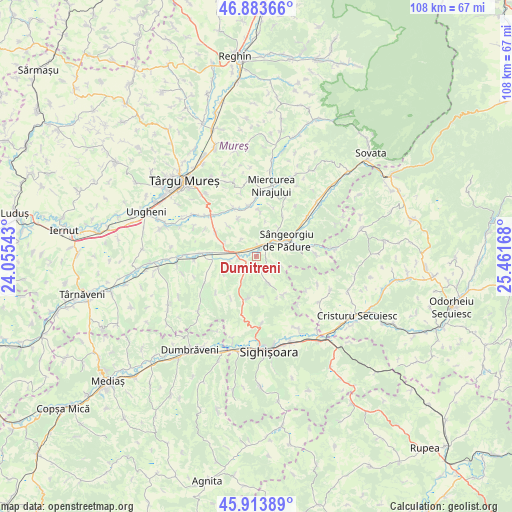
Dumitreni GPS coordinates[2]
46° 24' 3.348" North, 24° 45' 30.78" East
| Map corner | latitude | longitude |
|---|---|---|
| Upper-left | 46.88366°, | 24.05543° |
| Center: | 46.40093°, | 24.75855° |
| Lower-right: | 45.91389°, | 25.46168° |
| Map W x H: | 107.8×107.8 km | = 67×67mi |
| max Lat: | 48.23793° ⇑35.3% North |
| Dumitreni: | 46.40093° |
| min Lat: | ⇓64.7% South 43.65638° |
| min Long | Dumitreni | max Long |
| 20.31667° | 24.75855° | 29.65403° |
| W 43.7%⇐ | ⇒56.3% E |
Elevation
Elevation of Dumitreni is 346 m = 1135 ft, and this is 91.1 m = 299 ft above average elevation for this country.
| Max E: |
1278 m = 4193 ft | 26% |
| Dumitreni | 346 m 1135 ft | |
| Avg. | 254.9 m = 836 ft | |
Min E: |
-2 m = -7 ft | 74% |
See also: Romania elevation on elevation.city.
Geographical zone
Dumitreni is located in North temperate zone (between Tropic of Cancer and the Arctic Circle). Distance of this North polar circle is 2241.9 km =1393.1 mi to North.| Distance of | km | miles | from Dumitreni |
|---|---|---|---|
| North Pole | 4847.8 | 3012.3 | to North |
| Arctic Circle | 2241.9 | 1393.1 | to North |
| Tropic Cancer | 2553.4 | 1586.6 | to South |
| Equator | 5159.3 | 3205.8 | to South |


Nearby cities:
15 places around Dumitreni: (largest is in red/bold)
• Agrișteu
5.7 km =3.5 mi,  260°
260°
• Bălăuşeri
5.8 km =3.6 mi,  268°
268°
• Chendu
2.5 km =1.6 mi,  247°
247°
• Coroisânmartin
12.2 km =7.6 mi, 269°
• Călimănești
2.4 km =1.5 mi,  305°
305°
• Fântânele
1.9 km =1.2 mi,  339°
339°
• Nadeş
9.6 km =6 mi,  191°
191°
• Neaua
10.8 km =6.7 mi,  32°
32°
• Păsăreni
10.2 km =6.3 mi,  333°
333°
• Senereuș
11.1 km =6.9 mi,  228°
228°
• Sângeorgiu de Pădure
7.2 km =4.5 mi,  62°
62°
• Troița
9.3 km =5.8 mi,  5°
5°
• Veţca
6 km =3.7 mi,  161°
161°
• Viforoasa
5.2 km =3.2 mi,  48°
48°
• Țigmandru
6 km =3.7 mi,  211°
211°
Sources, notices
• [Note1] Compared only with cities in Romania existing in our database
• [Src1] Map data: © OpenStreetMap contributors (CC-BY-SA)
• [Src2] Other city data from geonames.org with taken over terms of usage.
• [Src3] Geographical zone / Annual Mean Temperature by Robert A. Rohde @ Wikipedia
