Fântânele geodata
Fântânele (Galaţi) is a populated place; located in Romania in Europe/Bucharest (GMT+3) time zone. With population of 1,768 people, there are 2853 cities with bigger population in this country. Compared to other cities in Romania, 52% of cities are located further ↑North; 96.3% of cities are located further ←West and 72.7% of cities have higher elevation than Fântânele. Note1


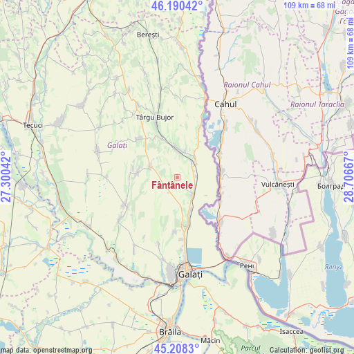
Fântânele GPS coordinates[2]
45° 42' 5.472" North, 28° 0' 12.744" East
| Map corner | latitude | longitude |
|---|---|---|
| Upper-left | 46.19042°, | 27.30042° |
| Center: | 45.70152°, | 28.00354° |
| Lower-right: | 45.2083°, | 28.70667° |
| Map W x H: | 109.2×109.2 km | = 67.9×67.9mi |
| max Lat: | 48.23793° ⇑52% North |
| Fântânele: | 45.70152° |
| min Lat: | ⇓48% South 43.65638° |
| min Long | Fântânele | max Long |
| 20.31667° | 28.00354° | 29.65403° |
| W 96.3%⇐ | ⇒3.7% E |
Elevation
Elevation of Fântânele is 118 m = 387 ft, and this is 136.9 m = 449 ft below average elevation for this country.
| Max E: |
1278 m = 4193 ft | 72.7% |
| Avg. | 254.9 m = 836 ft | |
| Fântânele | 118 m = 387 ft | |
Min E: |
-2 m = -7 ft | 27.3% |
See also: Romania elevation on elevation.city.
Geographical zone
Fântânele is located in North temperate zone (between Tropic of Cancer and the Arctic Circle). Distance of this North polar circle is 2319.6 km =1441.3 mi to North.| Distance of | km | miles | from Fântânele |
|---|---|---|---|
| North Pole | 4925.5 | 3060.6 | to North |
| Arctic Circle | 2319.6 | 1441.3 | to North |
| Tropic Cancer | 2475.6 | 1538.3 | to South |
| Equator | 5081.5 | 3157.5 | to South |


Nearby cities:
15 places around Fântânele: (largest is in red/bold)
• Brănești
12.9 km =8 mi,  29°
29°
• Chiraftei
8.1 km =5 mi,  13°
13°
• Cuca
10 km =6.2 mi,  290°
290°
• Folteşti
6.5 km =4 mi, 33°
• Frumuşiţa
6.3 km =3.9 mi,  128°
128°
• Fârţăneşti
12.9 km =8 mi,  353°
353°
• Ijdileni
8.5 km =5.3 mi,  150°
150°
• Măstăcani
9.4 km =5.8 mi, 14°
• Plevna
12.1 km =7.5 mi,  284°
284°
• Scânteiești
2.6 km =1.6 mi,  217°
217°
• Stoicani
5.8 km =3.6 mi,  86°
86°
• Tămăoani
6.1 km =3.8 mi,  113°
113°
• Tătarca
12 km =7.5 mi,  161°
161°
• Viile
12.5 km =7.8 mi,  339°
339°
• Șivița
10.7 km =6.6 mi, 156°
Sources, notices
• [Note1] Compared only with cities in Romania existing in our database
• [Src1] Map data: © OpenStreetMap contributors (CC-BY-SA)
• [Src2] Other city data from geonames.org with taken over terms of usage.
• [Src3] Geographical zone / Annual Mean Temperature by Robert A. Rohde @ Wikipedia
