Chiraftei geodata
Chiraftei (Galaţi) is a populated place; located in Romania in Europe/Bucharest (GMT+3) time zone. With population of 2,491 people, there are 2170 cities with bigger population in this country. Compared to other cities in Romania, 50.4% of cities are located further ↑North; 96.5% of cities are located further ←West and 91.3% of cities have higher elevation than Chiraftei. Note1


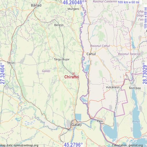
Chiraftei GPS coordinates[2]
45° 46' 19.92" North, 28° 1' 37.776" East
| Map corner | latitude | longitude |
|---|---|---|
| Upper-left | 46.26048°, | 27.32404° |
| Center: | 45.7722°, | 28.02716° |
| Lower-right: | 45.2796°, | 28.73029° |
| Map W x H: | 109.1×109.1 km | = 67.8×67.8mi |
| max Lat: | 48.23793° ⇑50.4% North |
| Chiraftei: | 45.7722° |
| min Lat: | ⇓49.6% South 43.65638° |
| min Long | Chiraftei | max Long |
| 20.31667° | 28.02716° | 29.65403° |
| W 96.5%⇐ | ⇒3.5% E |
Elevation
Elevation of Chiraftei is 52 m = 171 ft, and this is 202.9 m = 666 ft below average elevation for this country.
| Max E: |
1278 m = 4193 ft | 91.3% |
| Avg. | 254.9 m = 836 ft | |
| Chiraftei | 52 m = 171 ft | |
Min E: |
-2 m = -7 ft | 8.7% |
See also: Romania elevation on elevation.city.
Geographical zone
Chiraftei is located in North temperate zone (between Tropic of Cancer and the Arctic Circle). Distance of this North polar circle is 2311.8 km =1436.5 mi to North.| Distance of | km | miles | from Chiraftei |
|---|---|---|---|
| North Pole | 4917.7 | 3055.7 | to North |
| Arctic Circle | 2311.8 | 1436.5 | to North |
| Tropic Cancer | 2483.5 | 1543.2 | to South |
| Equator | 5089.4 | 3162.4 | to South |


Nearby cities:
15 places around Chiraftei: (largest is in red/bold)
• Brănești
5.6 km =3.5 mi,  53°
53°
• Cuca
12 km =7.5 mi,  248°
248°
• Folteşti
3 km =1.9 mi,  144°
144°
• Frumuşiţa
12.1 km =7.5 mi,  165°
165°
• Fântânele
8.1 km =5 mi,  193°
193°
• Fârţăneşti
6 km =3.7 mi,  325°
325°
• Măstăcani
1.3 km =0.8 mi,  21°
21°
• Plevna
14.4 km =8.9 mi, 250°
• Scânteiești
10.5 km =6.5 mi,  198°
198°
• Stoicani
8.5 km =5.3 mi,  152°
152°
• Târgu Bujor
14.4 km =8.9 mi,  316°
316°
• Tămăoani
11 km =6.8 mi,  160°
160°
• Umbrărești
11.9 km =7.4 mi, 315°
• Viile
7.3 km =4.5 mi,  301°
301°
• Vlădeşti
9.7 km =6 mi,  26°
26°
Sources, notices
• [Note1] Compared only with cities in Romania existing in our database
• [Src1] Map data: © OpenStreetMap contributors (CC-BY-SA)
• [Src2] Other city data from geonames.org with taken over terms of usage.
• [Src3] Geographical zone / Annual Mean Temperature by Robert A. Rohde @ Wikipedia
