Brebu geodata
Brebu (Dâmboviţa) is a populated place; located in Romania in Europe/Bucharest (GMT+3) time zone. With population of 709 people, there are 5514 cities with bigger population in this country. Compared to other cities in Romania, 61.9% of cities are located further ↑North; 51.9% of cities are located further ←West and 96.8% of cities have lower elevation than Brebu. Note1


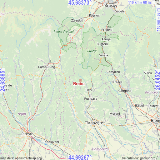
Brebu GPS coordinates[2]
45° 11' 25.296" North, 25° 20' 31.452" East
| Map corner | latitude | longitude |
|---|---|---|
| Upper-left | 45.68373°, | 24.63895° |
| Center: | 45.19036°, | 25.34207° |
| Lower-right: | 44.69267°, | 26.0452° |
| Map W x H: | 110.2×110.2 km | = 68.5×68.5mi |
| max Lat: | 48.23793° ⇑61.9% North |
| Brebu: | 45.19036° |
| min Lat: | ⇓38.1% South 43.65638° |
| min Long | Brebu | max Long |
| 20.31667° | 25.34207° | 29.65403° |
| W 51.9%⇐ | ⇒48.1% E |
Elevation
Elevation of Brebu is 705 m = 2313 ft, and this is 450.1 m = 1477 ft above average elevation for this country.
| Max E: |
1278 m = 4193 ft | 3.2% |
| Brebu | 705 m 2313 ft | |
| Avg. | 254.9 m = 836 ft | |
Min E: |
-2 m = -7 ft | 96.8% |
See also: Romania elevation on elevation.city.
Geographical zone
Brebu is located in North temperate zone (between Tropic of Cancer and the Arctic Circle). Distance of this North polar circle is 2376.5 km =1476.7 mi to North.| Distance of | km | miles | from Brebu |
|---|---|---|---|
| North Pole | 4982.4 | 3095.9 | to North |
| Arctic Circle | 2376.5 | 1476.7 | to North |
| Tropic Cancer | 2418.8 | 1503 | to South |
| Equator | 5024.7 | 3122.2 | to South |


Nearby cities:
15 places around Brebu: (largest is in red/bold)
• Bădeni
6.3 km =3.9 mi,  131°
131°
• Bărbuleţu
7.1 km =4.4 mi,  207°
207°
• Cetățuia
4.8 km =3 mi,  227°
227°
• Costești
6.3 km =3.9 mi,  143°
143°
• Dealu Frumos
5.6 km =3.5 mi,  95°
95°
• Ferestre
4.3 km =2.7 mi, 102°
• Lunca
8 km =5 mi,  82°
82°
• Moroeni
7.7 km =4.8 mi,  67°
67°
• Piatra
4.9 km =3 mi,  121°
121°
• Pietroşiţa
7.2 km =4.5 mi, 96°
• Pucheni
4.7 km =2.9 mi,  260°
260°
• Runcu
3.3 km =2.1 mi, 103°
• Râu Alb de Jos
6 km =3.7 mi,  175°
175°
• Râu Alb de Sus
3.5 km =2.2 mi,  199°
199°
• Siliștea
3.6 km =2.2 mi,  88°
88°
Sources, notices
• [Note1] Compared only with cities in Romania existing in our database
• [Src1] Map data: © OpenStreetMap contributors (CC-BY-SA)
• [Src2] Other city data from geonames.org with taken over terms of usage.
• [Src3] Geographical zone / Annual Mean Temperature by Robert A. Rohde @ Wikipedia
