Feneș geodata
Feneș (Caraş-Severin) is a populated place; located in Romania in Europe/Bucharest (GMT+3) time zone. With population of 856 people, there are 4811 cities with bigger population in this country. Compared to other cities in Romania, 61.9% of cities are located further ↑North; 91.2% of cities are located further →East and 78.9% of cities have lower elevation than Feneș. Note1


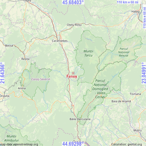
Feneș GPS coordinates[2]
45° 11' 26.376" North, 22° 20' 48.408" East
| Map corner | latitude | longitude |
|---|---|---|
| Upper-left | 45.68403°, | 21.64366° |
| Center: | 45.19066°, | 22.34678° |
| Lower-right: | 44.69298°, | 23.04991° |
| Map W x H: | 110.2×110.2 km | = 68.5×68.5mi |
| max Lat: | 48.23793° ⇑61.9% North |
| Feneș: | 45.19066° |
| min Lat: | ⇓38.1% South 43.65638° |
| min Long | Feneș | max Long |
| 20.31667° | 22.34678° | 29.65403° |
| W 8.8%⇐ | ⇒91.2% E |
Elevation
Elevation of Feneș is 383 m = 1257 ft, and this is 128.1 m = 420 ft above average elevation for this country.
| Max E: |
1278 m = 4193 ft | 21.1% |
| Feneș | 383 m 1257 ft | |
| Avg. | 254.9 m = 836 ft | |
Min E: |
-2 m = -7 ft | 78.9% |
See also: Romania elevation on elevation.city.
Geographical zone
Feneș is located in North temperate zone (between Tropic of Cancer and the Arctic Circle). Distance of this North polar circle is 2376.4 km =1476.6 mi to North.| Distance of | km | miles | from Feneș |
|---|---|---|---|
| North Pole | 4982.3 | 3095.9 | to North |
| Arctic Circle | 2376.4 | 1476.6 | to North |
| Tropic Cancer | 2418.8 | 1503 | to South |
| Equator | 5024.7 | 3122.2 | to South |


Nearby cities:
15 places around Feneș: (largest is in red/bold)
• Armeniş
2.6 km =1.6 mi,  293°
293°
• Brebu Nou
17.4 km =10.8 mi, 285°
• Bucoşniţa
13.7 km =8.5 mi,  332°
332°
• Cornereva
14.8 km =9.2 mi,  158°
158°
• Domaşnea
12.2 km =7.6 mi,  191°
191°
• Goleț
12.5 km =7.8 mi, 325°
• Ilova
9.7 km =6 mi,  357°
357°
• Luncaviţa
13.5 km =8.4 mi,  207°
207°
• Petroșnița
16.3 km =10.1 mi,  335°
335°
• Rusca
5.1 km =3.2 mi, 187°
• Slatina-Timiş
8.3 km =5.2 mi,  323°
323°
• Teregova
6.7 km =4.2 mi,  227°
227°
• Verendin
15.1 km =9.4 mi, 213°
• Vârciorova
15.2 km =9.4 mi,  1°
1°
• Vălișoara
14.9 km =9.3 mi, 341°
Sources, notices
• [Note1] Compared only with cities in Romania existing in our database
• [Src1] Map data: © OpenStreetMap contributors (CC-BY-SA)
• [Src2] Other city data from geonames.org with taken over terms of usage.
• [Src3] Geographical zone / Annual Mean Temperature by Robert A. Rohde @ Wikipedia
