Cornereva geodata
Cornereva (Caraş-Severin) is a seat of a second-order administrative division; located in Romania in Europe/Bucharest (GMT+3) time zone. With population of 3,291 people, there are 1558 cities with bigger population in this country. Compared to other cities in Romania, 67.1% of cities are located further ↑North; 90.5% of cities are located further →East and 94.1% of cities have lower elevation than Cornereva. Note1


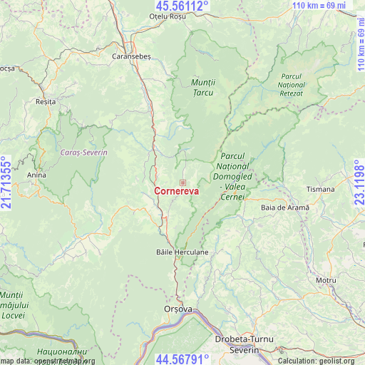
Cornereva GPS coordinates[2]
45° 4' 0.012" North, 22° 25' 0.012" East
| Map corner | latitude | longitude |
|---|---|---|
| Upper-left | 45.56112°, | 21.71355° |
| Center: | 45.06667°, | 22.41667° |
| Lower-right: | 44.56791°, | 23.1198° |
| Map W x H: | 110.4×110.4 km | = 68.6×68.6mi |
| max Lat: | 48.23793° ⇑67.1% North |
| Cornereva: | 45.06667° |
| min Lat: | ⇓32.9% South 43.65638° |
| min Long | Cornereva | max Long |
| 20.31667° | 22.41667° | 29.65403° |
| W 9.5%⇐ | ⇒90.5% E |
Elevation
Elevation of Cornereva is 600 m = 1969 ft, and this is 345.1 m = 1132 ft above average elevation for this country.
| Max E: |
1278 m = 4193 ft | 5.9% |
| Cornereva | 600 m 1969 ft | |
| Avg. | 254.9 m = 836 ft | |
Min E: |
-2 m = -7 ft | 94.1% |
See also: Romania elevation on elevation.city.
Geographical zone
Cornereva is located in North temperate zone (between Tropic of Cancer and the Arctic Circle). Distance of this North polar circle is 2390.2 km =1485.2 mi to North.| Distance of | km | miles | from Cornereva |
|---|---|---|---|
| North Pole | 4996.1 | 3104.4 | to North |
| Arctic Circle | 2390.2 | 1485.2 | to North |
| Tropic Cancer | 2405 | 1494.4 | to South |
| Equator | 5010.9 | 3113.6 | to South |


Nearby cities:
15 places around Cornereva: (largest is in red/bold)
• Cornea
8.7 km =5.4 mi,  244°
244°
• Crușovăț
10.8 km =6.7 mi,  224°
224°
• Cuptoare
10.5 km =6.5 mi,  233°
233°
• Domaşnea
8.1 km =5 mi,  283°
283°
• Feneș
14.8 km =9.2 mi,  338°
338°
• Globu Craiovei
13.9 km =8.6 mi, 235°
• Iablaniţa
15.2 km =9.4 mi,  211°
211°
• Luncaviţa
11.9 km =7.4 mi, 278°
• Mehadica
12.4 km =7.7 mi,  252°
252°
• Petnic
14 km =8.7 mi, 225°
• Plugova
12.4 km =7.7 mi,  201°
201°
• Rusca
10.7 km =6.6 mi,  324°
324°
• Teregova
14 km =8.7 mi,  311°
311°
• Valea Bolvașnița
13.6 km =8.5 mi,  188°
188°
• Verendin
14 km =8.7 mi,  274°
274°
Sources, notices
• [Note1] Compared only with cities in Romania existing in our database
• [Src1] Map data: © OpenStreetMap contributors (CC-BY-SA)
• [Src2] Other city data from geonames.org with taken over terms of usage.
• [Src3] Geographical zone / Annual Mean Temperature by Robert A. Rohde @ Wikipedia
