Verendin geodata
Verendin (Caraş-Severin) is a populated place; located in Romania in Europe/Bucharest (GMT+3) time zone. With population of 2,016 people, there are 2582 cities with bigger population in this country. Compared to other cities in Romania, 66.6% of cities are located further ↑North; 92.4% of cities are located further →East and 89.6% of cities have lower elevation than Verendin. Note1


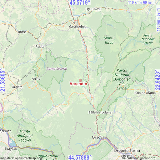
Verendin GPS coordinates[2]
45° 4' 39.18" North, 22° 14' 21.012" East
| Map corner | latitude | longitude |
|---|---|---|
| Upper-left | 45.5719°, | 21.53605° |
| Center: | 45.07755°, | 22.23917° |
| Lower-right: | 44.57888°, | 22.9423° |
| Map W x H: | 110.4×110.4 km | = 68.6×68.6mi |
| max Lat: | 48.23793° ⇑66.6% North |
| Verendin: | 45.07755° |
| min Lat: | ⇓33.4% South 43.65638° |
| min Long | Verendin | max Long |
| 20.31667° | 22.23917° | 29.65403° |
| W 7.6%⇐ | ⇒92.4% E |
Elevation
Elevation of Verendin is 507 m = 1663 ft, and this is 252.1 m = 827 ft above average elevation for this country.
| Max E: |
1278 m = 4193 ft | 10.4% |
| Verendin | 507 m 1663 ft | |
| Avg. | 254.9 m = 836 ft | |
Min E: |
-2 m = -7 ft | 89.6% |
See also: Romania elevation on elevation.city.
Geographical zone
Verendin is located in North temperate zone (between Tropic of Cancer and the Arctic Circle). Distance of this North polar circle is 2389 km =1484.5 mi to North.| Distance of | km | miles | from Verendin |
|---|---|---|---|
| North Pole | 4994.9 | 3103.7 | to North |
| Arctic Circle | 2389 | 1484.5 | to North |
| Tropic Cancer | 2406.2 | 1495.1 | to South |
| Equator | 5012.2 | 3114.4 | to South |


Nearby cities:
15 places around Verendin: (largest is in red/bold)
• Armeniş
14.9 km =9.3 mi,  24°
24°
• Borlovenii Noi
14.2 km =8.8 mi,  211°
211°
• Cornea
7.8 km =4.8 mi,  128°
128°
• Cornereva
14 km =8.7 mi,  94°
94°
• Crușovăț
11 km =6.8 mi,  144°
144°
• Cuptoare
9.2 km =5.7 mi, 143°
• Domaşnea
6.1 km =3.8 mi,  83°
83°
• Globu Craiovei
9.5 km =5.9 mi,  164°
164°
• Luncaviţa
2.3 km =1.4 mi,  73°
73°
• Lăpuşnicel
10.6 km =6.6 mi,  185°
185°
• Mehadica
5.4 km =3.4 mi, 156°
• Petnic
11.8 km =7.3 mi, 159°
• Pârvova
7.4 km =4.6 mi,  200°
200°
• Rusca
10.8 km =6.7 mi,  46°
46°
• Teregova
8.8 km =5.5 mi, 23°
Sources, notices
• [Note1] Compared only with cities in Romania existing in our database
• [Src1] Map data: © OpenStreetMap contributors (CC-BY-SA)
• [Src2] Other city data from geonames.org with taken over terms of usage.
• [Src3] Geographical zone / Annual Mean Temperature by Robert A. Rohde @ Wikipedia
