Teregova geodata
Teregova (Caraş-Severin) is a seat of a second-order administrative division; located in Romania in Europe/Bucharest (GMT+3) time zone. With population of 4,207 people, there are 1088 cities with bigger population in this country. Compared to other cities in Romania, 63.6% of cities are located further ↑North; 91.9% of cities are located further →East and 83.8% of cities have lower elevation than Teregova. Note1


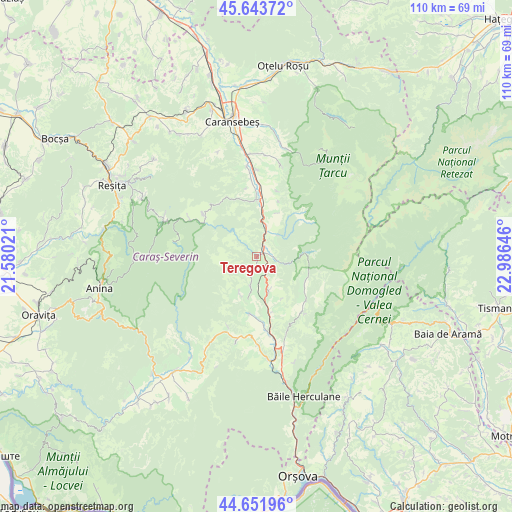
Teregova GPS coordinates[2]
45° 9' 0" North, 22° 16' 59.988" East
| Map corner | latitude | longitude |
|---|---|---|
| Upper-left | 45.64372°, | 21.58021° |
| Center: | 45.15°, | 22.28333° |
| Lower-right: | 44.65196°, | 22.98646° |
| Map W x H: | 110.3×110.3 km | = 68.5×68.5mi |
| max Lat: | 48.23793° ⇑63.6% North |
| Teregova: | 45.15° |
| min Lat: | ⇓36.4% South 43.65638° |
| min Long | Teregova | max Long |
| 20.31667° | 22.28333° | 29.65403° |
| W 8.1%⇐ | ⇒91.9% E |
Elevation
Elevation of Teregova is 432 m = 1417 ft, and this is 177.1 m = 581 ft above average elevation for this country.
| Max E: |
1278 m = 4193 ft | 16.2% |
| Teregova | 432 m 1417 ft | |
| Avg. | 254.9 m = 836 ft | |
Min E: |
-2 m = -7 ft | 83.8% |
See also: Romania elevation on elevation.city.
Geographical zone
Teregova is located in North temperate zone (between Tropic of Cancer and the Arctic Circle). Distance of this North polar circle is 2381 km =1479.5 mi to North.| Distance of | km | miles | from Teregova |
|---|---|---|---|
| North Pole | 4986.9 | 3098.7 | to North |
| Arctic Circle | 2381 | 1479.5 | to North |
| Tropic Cancer | 2414.3 | 1500.2 | to South |
| Equator | 5020.2 | 3119.4 | to South |


Nearby cities:
15 places around Teregova: (largest is in red/bold)
• Armeniş
6.1 km =3.8 mi,  25°
25°
• Brebu Nou
15 km =9.3 mi,  308°
308°
• Cornea
13.2 km =8.2 mi,  168°
168°
• Cornereva
14 km =8.7 mi,  131°
131°
• Cuptoare
15.6 km =9.7 mi, 172°
• Domaşnea
7.9 km =4.9 mi,  160°
160°
• Feneș
6.7 km =4.2 mi,  47°
47°
• Goleț
15 km =9.3 mi,  351°
351°
• Ilova
14.9 km =9.3 mi,  17°
17°
• Luncaviţa
7.5 km =4.7 mi,  190°
190°
• Mehadica
13 km =8.1 mi, 185°
• Pârvova
16.2 km =10.1 mi,  202°
202°
• Rusca
4.4 km =2.7 mi,  97°
97°
• Slatina-Timiş
11.1 km =6.9 mi,  0°
0°
• Verendin
8.8 km =5.5 mi, 203°
Sources, notices
• [Note1] Compared only with cities in Romania existing in our database
• [Src1] Map data: © OpenStreetMap contributors (CC-BY-SA)
• [Src2] Other city data from geonames.org with taken over terms of usage.
• [Src3] Geographical zone / Annual Mean Temperature by Robert A. Rohde @ Wikipedia
