Feldioara geodata
Feldioara (Cluj) is a populated place; located in Romania in Europe/Bucharest (GMT+3) time zone. With population of 628 people, there are 6022 cities with bigger population in this country. Compared to other cities in Romania, 76.1% of cities are located further ↓South; 66.7% of cities are located further →East and 72.7% of cities have lower elevation than Feldioara. Note1


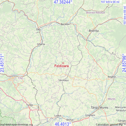
Feldioara GPS coordinates[2]
46° 53' 2.472" North, 24° 9' 17.388" East
| Map corner | latitude | longitude |
|---|---|---|
| Upper-left | 47.36244°, | 23.45171° |
| Center: | 46.88402°, | 24.15483° |
| Lower-right: | 46.4013°, | 24.85796° |
| Map W x H: | 106.9×106.9 km | = 66.4×66.4mi |
| max Lat: | 48.23793° ⇑23.9% North |
| Feldioara: | 46.88402° |
| min Lat: | ⇓76.1% South 43.65638° |
| min Long | Feldioara | max Long |
| 20.31667° | 24.15483° | 29.65403° |
| W 33.3%⇐ | ⇒66.7% E |
Elevation
Elevation of Feldioara is 338 m = 1109 ft, and this is 83.1 m = 273 ft above average elevation for this country.
| Max E: |
1278 m = 4193 ft | 27.3% |
| Feldioara | 338 m 1109 ft | |
| Avg. | 254.9 m = 836 ft | |
Min E: |
-2 m = -7 ft | 72.7% |
See also: Romania elevation on elevation.city.
Geographical zone
Feldioara is located in North temperate zone (between Tropic of Cancer and the Arctic Circle). Distance of this North polar circle is 2188.2 km =1359.7 mi to North.| Distance of | km | miles | from Feldioara |
|---|---|---|---|
| North Pole | 4794 | 2978.9 | to North |
| Arctic Circle | 2188.2 | 1359.7 | to North |
| Tropic Cancer | 2607.1 | 1620 | to South |
| Equator | 5213 | 3239.2 | to South |


Nearby cities:
15 places around Feldioara: (largest is in red/bold)
• Budeşti
7.2 km =4.5 mi,  90°
90°
• Buza
1.8 km =1.1 mi,  348°
348°
• Chiochiş
11.3 km =7 mi,  11°
11°
• Cămăraşu
11.3 km =7 mi,  188°
188°
• Cătina
4.4 km =2.7 mi,  150°
150°
• Fântânele
11 km =6.8 mi,  55°
55°
• Geaca
4.6 km =2.9 mi,  245°
245°
• Jimbor
6.2 km =3.9 mi,  41°
41°
• Miceştii de Câmpie
12.5 km =7.8 mi,  98°
98°
• Năsal
7.5 km =4.7 mi,  334°
334°
• Sâmboleni
9.2 km =5.7 mi,  202°
202°
• Sărmășel-Gară
11.6 km =7.2 mi,  160°
160°
• Visuia
11.9 km =7.4 mi,  116°
116°
• Ţaga
10.8 km =6.7 mi,  312°
312°
• Țagu
9.3 km =5.8 mi,  139°
139°
Sources, notices
• [Note1] Compared only with cities in Romania existing in our database
• [Src1] Map data: © OpenStreetMap contributors (CC-BY-SA)
• [Src2] Other city data from geonames.org with taken over terms of usage.
• [Src3] Geographical zone / Annual Mean Temperature by Robert A. Rohde @ Wikipedia
