Chiochiş geodata
Chiochiş (Bistriţa-Năsăud) is a seat of a second-order administrative division; located in Romania in Europe/Bucharest (GMT+3) time zone. With population of 3,520 people, there are 1415 cities with bigger population in this country. Compared to other cities in Romania, 78.5% of cities are located further ↓South; 66.3% of cities are located further →East and 72.8% of cities have lower elevation than Chiochiş. Note1


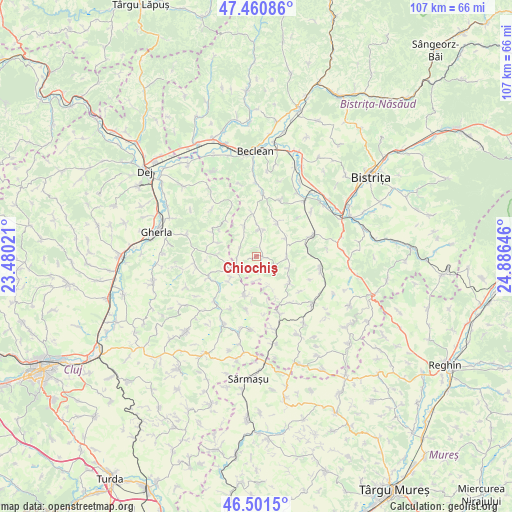
Chiochiş GPS coordinates[2]
46° 58' 59.988" North, 24° 10' 59.988" East
| Map corner | latitude | longitude |
|---|---|---|
| Upper-left | 47.46086°, | 23.48021° |
| Center: | 46.98333°, | 24.18333° |
| Lower-right: | 46.5015°, | 24.88646° |
| Map W x H: | 106.7×106.7 km | = 66.3×66.3mi |
| max Lat: | 48.23793° ⇑21.5% North |
| Chiochiş: | 46.98333° |
| min Lat: | ⇓78.5% South 43.65638° |
| min Long | Chiochiş | max Long |
| 20.31667° | 24.18333° | 29.65403° |
| W 33.7%⇐ | ⇒66.3% E |
Elevation
Elevation of Chiochiş is 339 m = 1112 ft, and this is 84.1 m = 276 ft above average elevation for this country.
| Max E: |
1278 m = 4193 ft | 27.2% |
| Chiochiş | 339 m 1112 ft | |
| Avg. | 254.9 m = 836 ft | |
Min E: |
-2 m = -7 ft | 72.8% |
See also: Romania elevation on elevation.city.
Geographical zone
Chiochiş is located in North temperate zone (between Tropic of Cancer and the Arctic Circle). Distance of this North polar circle is 2177.1 km =1352.8 mi to North.| Distance of | km | miles | from Chiochiş |
|---|---|---|---|
| North Pole | 4783 | 2972 | to North |
| Arctic Circle | 2177.1 | 1352.8 | to North |
| Tropic Cancer | 2618.1 | 1626.8 | to South |
| Equator | 5224.1 | 3246.1 | to South |


Nearby cities:
15 places around Chiochiş: (largest is in red/bold)
• Beudiu
8.9 km =5.5 mi,  354°
354°
• Bozieș
5.7 km =3.5 mi,  6°
6°
• Budeşti
12.2 km =7.6 mi,  155°
155°
• Buza
9.6 km =6 mi,  195°
195°
• Corvinești
6.9 km =4.3 mi,  57°
57°
• Cutca
9.6 km =6 mi,  304°
304°
• Feldioara
11.3 km =7 mi,  191°
191°
• Fântânele
8.3 km =5.2 mi,  124°
124°
• Jimbor
6.6 km =4.1 mi, 163°
• Matei
6.3 km =3.9 mi,  90°
90°
• Nuşeni
13 km =8.1 mi, 5°
• Năsal
6.9 km =4.3 mi,  231°
231°
• Sânmărtin
8.5 km =5.3 mi,  290°
290°
• Vermeș
10.3 km =6.4 mi,  79°
79°
• Ţaga
10.8 km =6.7 mi,  249°
249°
Sources, notices
• [Note1] Compared only with cities in Romania existing in our database
• [Src1] Map data: © OpenStreetMap contributors (CC-BY-SA)
• [Src2] Other city data from geonames.org with taken over terms of usage.
• [Src3] Geographical zone / Annual Mean Temperature by Robert A. Rohde @ Wikipedia
