Enăchești geodata
Enăchești (Bacău) is a populated place; located in Romania in Europe/Bucharest (GMT+3) time zone. With population of 810 people, there are 4993 cities with bigger population in this country. Compared to other cities in Romania, 67% of cities are located further ↓South; 76.8% of cities are located further ←West and 66.7% of cities have lower elevation than Enăchești. Note1


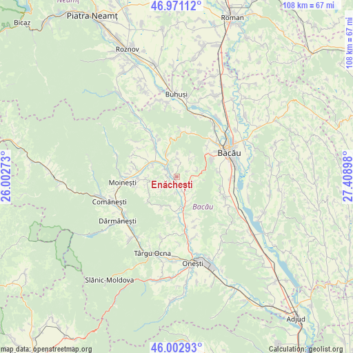
Enăchești GPS coordinates[2]
46° 29' 21.048" North, 26° 42' 21.06" East
| Map corner | latitude | longitude |
|---|---|---|
| Upper-left | 46.97112°, | 26.00273° |
| Center: | 46.48918°, | 26.70585° |
| Lower-right: | 46.00293°, | 27.40898° |
| Map W x H: | 107.7×107.7 km | = 66.9×66.9mi |
| max Lat: | 48.23793° ⇑33% North |
| Enăchești: | 46.48918° |
| min Lat: | ⇓67% South 43.65638° |
| min Long | Enăchești | max Long |
| 20.31667° | 26.70585° | 29.65403° |
| W 76.8%⇐ | ⇒23.2% E |
Elevation
Elevation of Enăchești is 300 m = 984 ft, and this is 45.1 m = 148 ft above average elevation for this country.
| Max E: |
1278 m = 4193 ft | 33.3% |
| Enăchești | 300 m 984 ft | |
| Avg. | 254.9 m = 836 ft | |
Min E: |
-2 m = -7 ft | 66.7% |
See also: Romania elevation on elevation.city.
Geographical zone
Enăchești is located in North temperate zone (between Tropic of Cancer and the Arctic Circle). Distance of this North polar circle is 2232.1 km =1387 mi to North.| Distance of | km | miles | from Enăchești |
|---|---|---|---|
| North Pole | 4837.9 | 3006.1 | to North |
| Arctic Circle | 2232.1 | 1387 | to North |
| Tropic Cancer | 2563.2 | 1592.7 | to South |
| Equator | 5169.1 | 3211.9 | to South |


Nearby cities:
15 places around Enăchești: (largest is in red/bold)
• Bereşti-Tazlău
3.9 km =2.4 mi,  230°
230°
• Coman
5.1 km =3.2 mi,  109°
109°
• Florești
4.9 km =3 mi,  322°
322°
• Leontinești
9.2 km =5.7 mi,  289°
289°
• Livezi
9.5 km =5.9 mi,  165°
165°
• Livezi-Vale
8.3 km =5.2 mi, 165°
• Orășa
8 km =5 mi,  158°
158°
• Prajoaia
9.3 km =5.8 mi, 173°
• Prisaca
2.8 km =1.7 mi, 161°
• Scorţeni
8 km =5 mi,  327°
327°
• Strugari
5 km =3.1 mi,  9°
9°
• Sănduleni
4.8 km =3 mi,  154°
154°
• Tescani
4.6 km =2.9 mi,  303°
303°
• Turluianu
6.1 km =3.8 mi, 228°
• Verșești
4.5 km =2.8 mi,  183°
183°
Sources, notices
• [Note1] Compared only with cities in Romania existing in our database
• [Src1] Map data: © OpenStreetMap contributors (CC-BY-SA)
• [Src2] Other city data from geonames.org with taken over terms of usage.
• [Src3] Geographical zone / Annual Mean Temperature by Robert A. Rohde @ Wikipedia
