Scorţeni geodata
Scorţeni (Bacău) is a seat of a second-order administrative division; located in Romania in Europe/Bucharest (GMT+3) time zone. With population of 3,159 people, there are 1649 cities with bigger population in this country. Compared to other cities in Romania, 68.1% of cities are located further ↓South; 75.5% of cities are located further ←West and 66.4% of cities have lower elevation than Scorţeni. Note1


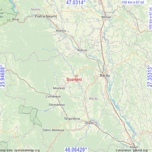
Scorţeni GPS coordinates[2]
46° 33' 0" North, 26° 39' 0" East
| Map corner | latitude | longitude |
|---|---|---|
| Upper-left | 47.0314°, | 25.94688° |
| Center: | 46.55°, | 26.65° |
| Lower-right: | 46.06429°, | 27.35313° |
| Map W x H: | 107.5×107.5 km | = 66.8×66.8mi |
| max Lat: | 48.23793° ⇑31.9% North |
| Scorţeni: | 46.55° |
| min Lat: | ⇓68.1% South 43.65638° |
| min Long | Scorţeni | max Long |
| 20.31667° | 26.65° | 29.65403° |
| W 75.5%⇐ | ⇒24.5% E |
Elevation
Elevation of Scorţeni is 299 m = 981 ft, and this is 44.1 m = 145 ft above average elevation for this country.
| Max E: |
1278 m = 4193 ft | 33.6% |
| Scorţeni | 299 m 981 ft | |
| Avg. | 254.9 m = 836 ft | |
Min E: |
-2 m = -7 ft | 66.4% |
See also: Romania elevation on elevation.city.
Geographical zone
Scorţeni is located in North temperate zone (between Tropic of Cancer and the Arctic Circle). Distance of this North polar circle is 2225.3 km =1382.7 mi to North.| Distance of | km | miles | from Scorţeni |
|---|---|---|---|
| North Pole | 4831.2 | 3002 | to North |
| Arctic Circle | 2225.3 | 1382.7 | to North |
| Tropic Cancer | 2570 | 1596.9 | to South |
| Equator | 5175.9 | 3216.2 | to South |


Nearby cities:
15 places around Scorţeni: (largest is in red/bold)
• Ardeoani
4.2 km =2.6 mi,  244°
244°
• Bucșești
9 km =5.6 mi,  215°
215°
• Băhnășeni
5.8 km =3.6 mi,  295°
295°
• Băsăști
9.1 km =5.7 mi,  336°
336°
• Câmpeni
5.9 km =3.7 mi, 342°
• Enăchești
8 km =5 mi,  147°
147°
• Florești
3.1 km =1.9 mi,  156°
156°
• Grigoreni
5.7 km =3.5 mi,  25°
25°
• Leontinești
5.7 km =3.5 mi,  229°
229°
• Măgireşti
8.5 km =5.3 mi, 244°
• Pustiana
4.7 km =2.9 mi, 341°
• Pârjol
5.3 km =3.3 mi,  314°
314°
• Strugari
5.4 km =3.4 mi,  109°
109°
• Sărata
7.7 km =4.8 mi,  284°
284°
• Tescani
4.3 km =2.7 mi,  173°
173°
Sources, notices
• [Note1] Compared only with cities in Romania existing in our database
• [Src1] Map data: © OpenStreetMap contributors (CC-BY-SA)
• [Src2] Other city data from geonames.org with taken over terms of usage.
• [Src3] Geographical zone / Annual Mean Temperature by Robert A. Rohde @ Wikipedia
