Florești geodata
Florești (Bacău) is a populated place; located in Romania in Europe/Bucharest (GMT+3) time zone. With population of 613 people, there are 6117 cities with bigger population in this country. Compared to other cities in Romania, 67.7% of cities are located further ↓South; 75.9% of cities are located further ←West and 64.9% of cities have lower elevation than Florești. Note1


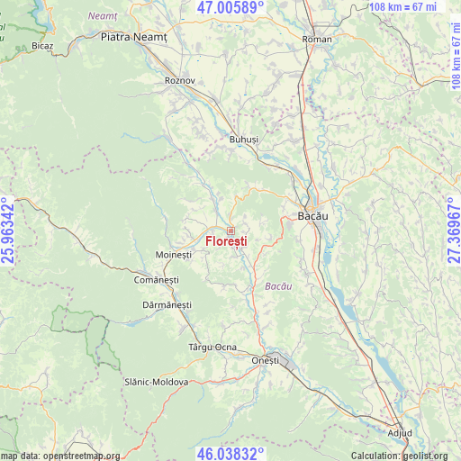
Florești GPS coordinates[2]
46° 31' 27.336" North, 26° 39' 59.544" East
| Map corner | latitude | longitude |
|---|---|---|
| Upper-left | 47.00589°, | 25.96342° |
| Center: | 46.52426°, | 26.66654° |
| Lower-right: | 46.03832°, | 27.36967° |
| Map W x H: | 107.6×107.6 km | = 66.9×66.9mi |
| max Lat: | 48.23793° ⇑32.3% North |
| Florești: | 46.52426° |
| min Lat: | ⇓67.7% South 43.65638° |
| min Long | Florești | max Long |
| 20.31667° | 26.66654° | 29.65403° |
| W 75.9%⇐ | ⇒24.1% E |
Elevation
Elevation of Florești is 289 m = 948 ft, and this is 34.1 m = 112 ft above average elevation for this country.
| Max E: |
1278 m = 4193 ft | 35.1% |
| Florești | 289 m 948 ft | |
| Avg. | 254.9 m = 836 ft | |
Min E: |
-2 m = -7 ft | 64.9% |
See also: Romania elevation on elevation.city.
Geographical zone
Florești is located in North temperate zone (between Tropic of Cancer and the Arctic Circle). Distance of this North polar circle is 2228.2 km =1384.5 mi to North.| Distance of | km | miles | from Florești |
|---|---|---|---|
| North Pole | 4834 | 3003.7 | to North |
| Arctic Circle | 2228.2 | 1384.5 | to North |
| Tropic Cancer | 2567.1 | 1595.1 | to South |
| Equator | 5173 | 3214.4 | to South |


Nearby cities:
15 places around Florești: (largest is in red/bold)
• Ardeoani
5.2 km =3.2 mi,  281°
281°
• Bereşti-Tazlău
6.4 km =4 mi,  179°
179°
• Bucșești
7.9 km =4.9 mi,  235°
235°
• Băhnășeni
8.4 km =5.2 mi,  309°
309°
• Cernu
8.7 km =5.4 mi,  226°
226°
• Enăchești
4.9 km =3 mi,  142°
142°
• Grigoreni
8.1 km =5 mi,  8°
8°
• Leontinești
5.7 km =3.5 mi,  261°
261°
• Prisaca
7.6 km =4.7 mi,  149°
149°
• Pustiana
7.8 km =4.8 mi,  339°
339°
• Pârjol
8.3 km =5.2 mi,  322°
322°
• Scorţeni
3.1 km =1.9 mi, 336°
• Strugari
4 km =2.5 mi,  75°
75°
• Tescani
1.6 km =1 mi,  209°
209°
• Turluianu
8.1 km =5 mi,  191°
191°
Sources, notices
• [Note1] Compared only with cities in Romania existing in our database
• [Src1] Map data: © OpenStreetMap contributors (CC-BY-SA)
• [Src2] Other city data from geonames.org with taken over terms of usage.
• [Src3] Geographical zone / Annual Mean Temperature by Robert A. Rohde @ Wikipedia
