Schitu-Goleşti geodata
Schitu-Goleşti (Arges) is a seat of a second-order administrative division; located in Romania in Europe/Bucharest (GMT+3) time zone. With population of 4,945 people, there are 807 cities with bigger population in this country. Compared to other cities in Romania, 61.7% of cities are located further ↑North; 52.6% of cities are located further →East and 89.8% of cities have lower elevation than Schitu-Goleşti. Note1


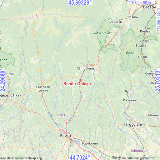
Schitu-Goleşti GPS coordinates[2]
45° 12' 0" North, 25° 0' 0" East
| Map corner | latitude | longitude |
|---|---|---|
| Upper-left | 45.69329°, | 24.29688° |
| Center: | 45.2°, | 25° |
| Lower-right: | 44.7024°, | 25.70313° |
| Map W x H: | 110.2×110.2 km | = 68.5×68.5mi |
| max Lat: | 48.23793° ⇑61.7% North |
| Schitu-Goleşti: | 45.2° |
| min Lat: | ⇓38.3% South 43.65638° |
| min Long | Schitu-Goleşti | max Long |
| 20.31667° | 25° | 29.65403° |
| W 47.4%⇐ | ⇒52.6% E |
Elevation
Elevation of Schitu-Goleşti is 509 m = 1670 ft, and this is 254.1 m = 834 ft above average elevation for this country.
| Max E: |
1278 m = 4193 ft | 10.2% |
| Schitu-Goleşti | 509 m 1670 ft | |
| Avg. | 254.9 m = 836 ft | |
Min E: |
-2 m = -7 ft | 89.8% |
See also: Romania elevation on elevation.city.
Geographical zone
Schitu-Goleşti is located in North temperate zone (between Tropic of Cancer and the Arctic Circle). Distance of this North polar circle is 2375.4 km =1476 mi to North.| Distance of | km | miles | from Schitu-Goleşti |
|---|---|---|---|
| North Pole | 4981.3 | 3095.2 | to North |
| Arctic Circle | 2375.4 | 1476 | to North |
| Tropic Cancer | 2419.8 | 1503.6 | to South |
| Equator | 5025.8 | 3122.9 | to South |


Nearby cities:
15 places around Schitu-Goleşti: (largest is in red/bold)
• Aninoasa
5.5 km =3.4 mi,  250°
250°
• Berevoeşti
7.5 km =4.7 mi,  299°
299°
• Bughea de Jos
7.4 km =4.6 mi,  0°
0°
• Capu Piscului
2.9 km =1.8 mi,  219°
219°
• Cotești
2 km =1.2 mi,  261°
261°
• Furnicoși
6.3 km =3.9 mi,  178°
178°
• Godeni
3.9 km =2.4 mi,  340°
340°
• Groșani
4.1 km =2.5 mi,  40°
40°
• Gămăcești
7.9 km =4.9 mi,  316°
316°
• Jugur
6.7 km =4.2 mi,  97°
97°
• Lăzărești
4.8 km =3 mi, 184°
• Mățău
7.6 km =4.7 mi,  58°
58°
• Poienari
4.3 km =2.7 mi, 64°
• Valea Pechii
1.4 km =0.9 mi,  136°
136°
• Valea Siliștii
7.3 km =4.5 mi, 261°
Sources, notices
• [Note1] Compared only with cities in Romania existing in our database
• [Src1] Map data: © OpenStreetMap contributors (CC-BY-SA)
• [Src2] Other city data from geonames.org with taken over terms of usage.
• [Src3] Geographical zone / Annual Mean Temperature by Robert A. Rohde @ Wikipedia
