Dobrun geodata
Dobrun (Olt) is a seat of a second-order administrative division; located in Romania in Europe/Bucharest (GMT+3) time zone. With population of 3,419 people, there are 1478 cities with bigger population in this country. Compared to other cities in Romania, 91.7% of cities are located further ↑North; 65.7% of cities are located further →East and 76.3% of cities have higher elevation than Dobrun. Note1


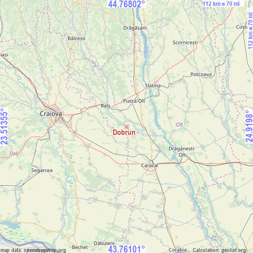
Dobrun GPS coordinates[2]
44° 16' 0.012" North, 24° 13' 0.012" East
| Map corner | latitude | longitude |
|---|---|---|
| Upper-left | 44.76802°, | 23.51355° |
| Center: | 44.26667°, | 24.21667° |
| Lower-right: | 43.76101°, | 24.9198° |
| Map W x H: | 112×112 km | = 69.6×69.6mi |
| max Lat: | 48.23793° ⇑91.7% North |
| Dobrun: | 44.26667° |
| min Lat: | ⇓8.3% South 43.65638° |
| min Long | Dobrun | max Long |
| 20.31667° | 24.21667° | 29.65403° |
| W 34.3%⇐ | ⇒65.7% E |
Elevation
Elevation of Dobrun is 106 m = 348 ft, and this is 148.9 m = 489 ft below average elevation for this country.
| Max E: |
1278 m = 4193 ft | 76.3% |
| Avg. | 254.9 m = 836 ft | |
| Dobrun | 106 m = 348 ft | |
Min E: |
-2 m = -7 ft | 23.7% |
See also: Romania elevation on elevation.city.
Geographical zone
Dobrun is located in North temperate zone (between Tropic of Cancer and the Arctic Circle). Distance of this Northern Tropic circle is 2316.1 km =1439.2 mi to South.| Distance of | km | miles | from Dobrun |
|---|---|---|---|
| North Pole | 5085.1 | 3159.7 | to North |
| Arctic Circle | 2479.2 | 1540.5 | to North |
| Tropic Cancer | 2316.1 | 1439.2 | to South |
| Equator | 4922 | 3058.4 | to South |


Nearby cities:
15 places around Dobrun: (largest is in red/bold)
• Braneț
7.3 km =4.5 mi,  334°
334°
• Brâncoveni
8.7 km =5.4 mi,  50°
50°
• Bârza
9.1 km =5.7 mi,  318°
318°
• Mărgăritești
6.5 km =4 mi,  302°
302°
• Olari
4.6 km =2.9 mi,  351°
351°
• Osica de Jos
5.6 km =3.5 mi,  116°
116°
• Osica de Sus
8.2 km =5.1 mi,  103°
103°
• Pârşcoveni
3.9 km =2.4 mi,  19°
19°
• Racovița
9.4 km =5.8 mi,  305°
305°
• Teslui
8.4 km =5.2 mi,  215°
215°
• Viișoara
9.2 km =5.7 mi,  245°
245°
• Vlăduleni
8.8 km =5.5 mi, 96°
• Voineasa
6.9 km =4.3 mi,  285°
285°
• Văleni
7.8 km =4.8 mi,  65°
65°
• Şopârliţa
5.6 km =3.5 mi, 70°
Sources, notices
• [Note1] Compared only with cities in Romania existing in our database
• [Src1] Map data: © OpenStreetMap contributors (CC-BY-SA)
• [Src2] Other city data from geonames.org with taken over terms of usage.
• [Src3] Geographical zone / Annual Mean Temperature by Robert A. Rohde @ Wikipedia
