Braneț geodata
Braneț (Olt) is a populated place; located in Romania in Europe/Bucharest (GMT+3) time zone. With population of 1,658 people, there are 2970 cities with bigger population in this country. Compared to other cities in Romania, 90.2% of cities are located further ↑North; 66.3% of cities are located further →East and 68.7% of cities have higher elevation than Braneț. Note1


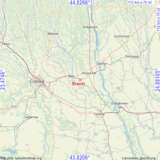
Braneț GPS coordinates[2]
44° 19' 32.736" North, 24° 10' 40.512" East
| Map corner | latitude | longitude |
|---|---|---|
| Upper-left | 44.8266°, | 23.4748° |
| Center: | 44.32576°, | 24.17792° |
| Lower-right: | 43.8206°, | 24.88105° |
| Map W x H: | 111.9×111.9 km | = 69.5×69.5mi |
| max Lat: | 48.23793° ⇑90.2% North |
| Braneț: | 44.32576° |
| min Lat: | ⇓9.8% South 43.65638° |
| min Long | Braneț | max Long |
| 20.31667° | 24.17792° | 29.65403° |
| W 33.7%⇐ | ⇒66.3% E |
Elevation
Elevation of Braneț is 132 m = 433 ft, and this is 122.9 m = 403 ft below average elevation for this country.
| Max E: |
1278 m = 4193 ft | 68.7% |
| Avg. | 254.9 m = 836 ft | |
| Braneț | 132 m = 433 ft | |
Min E: |
-2 m = -7 ft | 31.3% |
See also: Romania elevation on elevation.city.
Geographical zone
Braneț is located in North temperate zone (between Tropic of Cancer and the Arctic Circle). Distance of this Northern Tropic circle is 2322.6 km =1443.2 mi to South.| Distance of | km | miles | from Braneț |
|---|---|---|---|
| North Pole | 5078.5 | 3155.6 | to North |
| Arctic Circle | 2472.6 | 1536.4 | to North |
| Tropic Cancer | 2322.6 | 1443.2 | to South |
| Equator | 4928.6 | 3062.5 | to South |


Nearby cities:
15 places around Braneț: (largest is in red/bold)
• Balş
6.8 km =4.2 mi,  293°
293°
• Bistrița Nouă
9.1 km =5.7 mi,  26°
26°
• Bobiceşti
6.8 km =4.2 mi,  340°
340°
• Bârza
2.9 km =1.8 mi,  275°
275°
• Corbeni
8 km =5 mi,  317°
317°
• Dobrun
7.3 km =4.5 mi,  154°
154°
• Leotești
5 km =3.1 mi, 335°
• Mirila
4.1 km =2.5 mi,  329°
329°
• Mărgăritești
3.9 km =2.4 mi,  217°
217°
• Olari
3.1 km =1.9 mi,  129°
129°
• Piatra Olt
8.4 km =5.2 mi,  57°
57°
• Pârşcoveni
5.3 km =3.3 mi,  123°
123°
• Racovița
4.7 km =2.9 mi,  255°
255°
• Teiș
4.5 km =2.8 mi,  307°
307°
• Voineasa
5.9 km =3.7 mi, 216°
Sources, notices
• [Note1] Compared only with cities in Romania existing in our database
• [Src1] Map data: © OpenStreetMap contributors (CC-BY-SA)
• [Src2] Other city data from geonames.org with taken over terms of usage.
• [Src3] Geographical zone / Annual Mean Temperature by Robert A. Rohde @ Wikipedia
