Derșida geodata
Derșida (Sălaj) is a populated place; located in Romania in Europe/Bucharest (GMT+3) time zone. With population of 1,910 people, there are 2691 cities with bigger population in this country. Compared to other cities in Romania, 88.7% of cities are located further ↓South; 87% of cities are located further →East and 59.2% of cities have higher elevation than Derșida. Note1


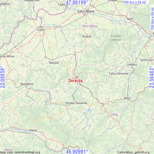
Derșida GPS coordinates[2]
47° 23' 17.16" North, 22° 48' 6.12" East
| Map corner | latitude | longitude |
|---|---|---|
| Upper-left | 47.86199°, | 22.09858° |
| Center: | 47.3881°, | 22.8017° |
| Lower-right: | 46.90991°, | 23.50483° |
| Map W x H: | 105.9×105.9 km | = 65.8×65.8mi |
| max Lat: | 48.23793° ⇑11.3% North |
| Derșida: | 47.3881° |
| min Lat: | ⇓88.7% South 43.65638° |
| min Long | Derșida | max Long |
| 20.31667° | 22.8017° | 29.65403° |
| W 13%⇐ | ⇒87% E |
Elevation
Elevation of Derșida is 169 m = 554 ft, and this is 85.9 m = 282 ft below average elevation for this country.
| Max E: |
1278 m = 4193 ft | 59.2% |
| Avg. | 254.9 m = 836 ft | |
| Derșida | 169 m = 554 ft | |
Min E: |
-2 m = -7 ft | 40.8% |
See also: Romania elevation on elevation.city.
Geographical zone
Derșida is located in North temperate zone (between Tropic of Cancer and the Arctic Circle). Distance of this North polar circle is 2132.1 km =1324.8 mi to North.| Distance of | km | miles | from Derșida |
|---|---|---|---|
| North Pole | 4738 | 2944.1 | to North |
| Arctic Circle | 2132.1 | 1324.8 | to North |
| Tropic Cancer | 2663.1 | 1654.8 | to South |
| Equator | 5269.1 | 3274.1 | to South |


Nearby cities:
15 places around Derșida: (largest is in red/bold)
• Bobota
2.7 km =1.7 mi,  258°
258°
• Bogdand
10.4 km =6.5 mi,  72°
72°
• Chieşd
6.2 km =3.9 mi,  94°
94°
• Corund
6.3 km =3.9 mi,  53°
53°
• Giorocuta
4.9 km =3 mi,  356°
356°
• Giurtelecu Șimleului
10.2 km =6.3 mi,  182°
182°
• Hurezu Mare
9 km =5.6 mi,  17°
17°
• Ilișua
10.5 km =6.5 mi,  164°
164°
• Lompirt
8 km =5 mi, 155°
• Măerişte
7.9 km =4.9 mi, 180°
• Sighetu Silvaniei
7.1 km =4.4 mi,  127°
127°
• Supuru de Jos
8.7 km =5.4 mi, 359°
• Sălăjeni
10.8 km =6.7 mi, 133°
• Zalnoc
9 km =5.6 mi, 255°
• Şărmăşag
4.9 km =3 mi,  150°
150°
Sources, notices
• [Note1] Compared only with cities in Romania existing in our database
• [Src1] Map data: © OpenStreetMap contributors (CC-BY-SA)
• [Src2] Other city data from geonames.org with taken over terms of usage.
• [Src3] Geographical zone / Annual Mean Temperature by Robert A. Rohde @ Wikipedia
