Crăciunei geodata
Crăciunei (Olt) is a populated place; located in Romania in Europe/Bucharest (GMT+3) time zone. With population of 1,050 people, there are 4124 cities with bigger population in this country. Compared to other cities in Romania, 94.5% of cities are located further ↑North; 57.8% of cities are located further →East and 72.9% of cities have higher elevation than Crăciunei. Note1


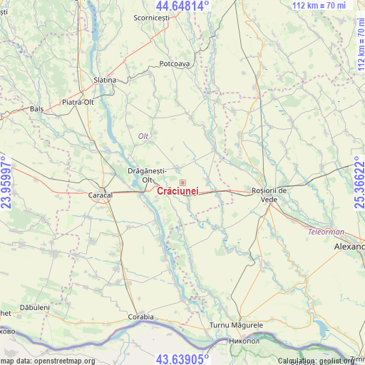
Crăciunei GPS coordinates[2]
44° 8' 44.7" North, 24° 39' 47.124" East
| Map corner | latitude | longitude |
|---|---|---|
| Upper-left | 44.64814°, | 23.95997° |
| Center: | 44.14575°, | 24.66309° |
| Lower-right: | 43.63905°, | 25.36622° |
| Map W x H: | 112.2×112.2 km | = 69.7×69.7mi |
| max Lat: | 48.23793° ⇑94.5% North |
| Crăciunei: | 44.14575° |
| min Lat: | ⇓5.5% South 43.65638° |
| min Long | Crăciunei | max Long |
| 20.31667° | 24.66309° | 29.65403° |
| W 42.2%⇐ | ⇒57.8% E |
Elevation
Elevation of Crăciunei is 117 m = 384 ft, and this is 137.9 m = 452 ft below average elevation for this country.
| Max E: |
1278 m = 4193 ft | 72.9% |
| Avg. | 254.9 m = 836 ft | |
| Crăciunei | 117 m = 384 ft | |
Min E: |
-2 m = -7 ft | 27.1% |
See also: Romania elevation on elevation.city.
Geographical zone
Crăciunei is located in North temperate zone (between Tropic of Cancer and the Arctic Circle). Distance of this Northern Tropic circle is 2302.6 km =1430.8 mi to South.| Distance of | km | miles | from Crăciunei |
|---|---|---|---|
| North Pole | 5098.5 | 3168.1 | to North |
| Arctic Circle | 2492.6 | 1548.8 | to North |
| Tropic Cancer | 2302.6 | 1430.8 | to South |
| Equator | 4908.5 | 3050 | to South |


Nearby cities:
15 places around Crăciunei: (largest is in red/bold)
• Berindei
8.9 km =5.5 mi,  242°
242°
• Bușca
11.7 km =7.3 mi,  108°
108°
• Bârseștii de Sus
12.5 km =7.8 mi,  178°
178°
• Cioflanu
9.9 km =6.2 mi,  234°
234°
• Călinești
7.9 km =4.9 mi,  165°
165°
• Drăgăneşti-Olt
10.6 km =6.6 mi,  282°
282°
• Dăneasa
7.7 km =4.8 mi,  273°
273°
• Gostavăţu
12.5 km =7.8 mi, 236°
• Mihăeşti
9.7 km =6 mi,  98°
98°
• Pestra
10.9 km =6.8 mi,  256°
256°
• Radomireşti
3.6 km =2.2 mi,  153°
153°
• Seaca
7.3 km =4.5 mi,  71°
71°
• Slăveni
12.7 km =7.9 mi, 238°
• Sprâncenata
7.3 km =4.5 mi,  198°
198°
• Stoicăneşti
4.8 km =3 mi,  330°
330°
Sources, notices
• [Note1] Compared only with cities in Romania existing in our database
• [Src1] Map data: © OpenStreetMap contributors (CC-BY-SA)
• [Src2] Other city data from geonames.org with taken over terms of usage.
• [Src3] Geographical zone / Annual Mean Temperature by Robert A. Rohde @ Wikipedia
