Stoicăneşti geodata
Stoicăneşti (Olt) is a seat of a second-order administrative division; located in Romania in Europe/Bucharest (GMT+3) time zone. With population of 3,015 people, there are 1753 cities with bigger population in this country. Compared to other cities in Romania, 93.8% of cities are located further ↑North; 58.4% of cities are located further →East and 68.7% of cities have higher elevation than Stoicăneşti. Note1


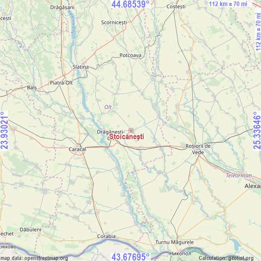
Stoicăneşti GPS coordinates[2]
44° 10' 59.988" North, 24° 37' 59.988" East
| Map corner | latitude | longitude |
|---|---|---|
| Upper-left | 44.68539°, | 23.93021° |
| Center: | 44.18333°, | 24.63333° |
| Lower-right: | 43.67695°, | 25.33646° |
| Map W x H: | 112.1×112.1 km | = 69.7×69.7mi |
| max Lat: | 48.23793° ⇑93.8% North |
| Stoicăneşti: | 44.18333° |
| min Lat: | ⇓6.2% South 43.65638° |
| min Long | Stoicăneşti | max Long |
| 20.31667° | 24.63333° | 29.65403° |
| W 41.6%⇐ | ⇒58.4% E |
Elevation
Elevation of Stoicăneşti is 132 m = 433 ft, and this is 122.9 m = 403 ft below average elevation for this country.
| Max E: |
1278 m = 4193 ft | 68.7% |
| Avg. | 254.9 m = 836 ft | |
| Stoicăneşti | 132 m = 433 ft | |
Min E: |
-2 m = -7 ft | 31.3% |
See also: Romania elevation on elevation.city.
Geographical zone
Stoicăneşti is located in North temperate zone (between Tropic of Cancer and the Arctic Circle). Distance of this Northern Tropic circle is 2306.8 km =1433.4 mi to South.| Distance of | km | miles | from Stoicăneşti |
|---|---|---|---|
| North Pole | 5094.3 | 3165.5 | to North |
| Arctic Circle | 2488.4 | 1546.2 | to North |
| Tropic Cancer | 2306.8 | 1433.4 | to South |
| Equator | 4912.7 | 3052.6 | to South |


Nearby cities:
15 places around Stoicăneşti: (largest is in red/bold)
• Alimănești
11.1 km =6.9 mi,  317°
317°
• Berindei
10 km =6.2 mi,  213°
213°
• Cioflanu
11.5 km =7.1 mi, 209°
• Comani
11.3 km =7 mi,  269°
269°
• Crăciunei
4.8 km =3 mi,  150°
150°
• Călinești
12.6 km =7.8 mi,  159°
159°
• Drăgăneşti-Olt
8.2 km =5.1 mi,  256°
256°
• Dăneasa
6.5 km =4 mi,  235°
235°
• Izvoarele
13.1 km =8.1 mi,  314°
314°
• Pestra
10.6 km =6.6 mi,  230°
230°
• Radomireşti
8.4 km =5.2 mi, 151°
• Seaca
9.5 km =5.9 mi,  101°
101°
• Sprâncenata
11.1 km =6.9 mi,  180°
180°
• Stoeneşti
13 km =8.1 mi, 235°
• Vâlcelele de Sus
12.8 km =8 mi,  332°
332°
Sources, notices
• [Note1] Compared only with cities in Romania existing in our database
• [Src1] Map data: © OpenStreetMap contributors (CC-BY-SA)
• [Src2] Other city data from geonames.org with taken over terms of usage.
• [Src3] Geographical zone / Annual Mean Temperature by Robert A. Rohde @ Wikipedia
