Daia geodata
Daia (Giurgiu) is a seat of a second-order administrative division; located in Romania in Europe/Bucharest (GMT+3) time zone. With population of 3,090 people, there are 1699 cities with bigger population in this country. Compared to other cities in Romania, 97% of cities are located further ↑North; 62.5% of cities are located further ←West and 88.2% of cities have higher elevation than Daia. Note1


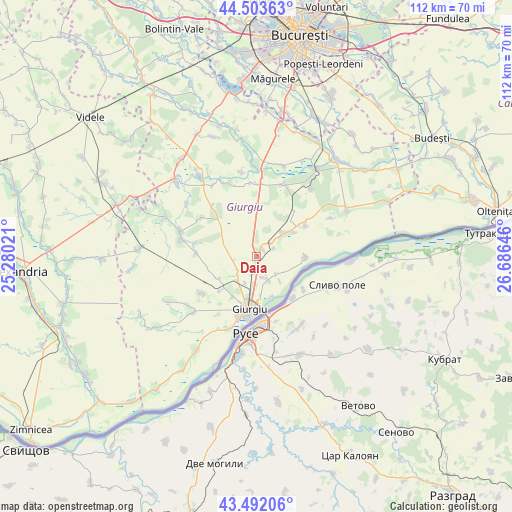
Daia GPS coordinates[2]
44° 0' 0" North, 25° 58' 59.988" East
| Map corner | latitude | longitude |
|---|---|---|
| Upper-left | 44.50363°, | 25.28021° |
| Center: | 44°, | 25.98333° |
| Lower-right: | 43.49206°, | 26.68646° |
| Map W x H: | 112.5×112.5 km | = 69.9×69.9mi |
| max Lat: | 48.23793° ⇑97% North |
| Daia: | 44° |
| min Lat: | ⇓3% South 43.65638° |
| min Long | Daia | max Long |
| 20.31667° | 25.98333° | 29.65403° |
| W 62.5%⇐ | ⇒37.5% E |
Elevation
Elevation of Daia is 66 m = 217 ft, and this is 188.9 m = 620 ft below average elevation for this country.
| Max E: |
1278 m = 4193 ft | 88.2% |
| Avg. | 254.9 m = 836 ft | |
| Daia | 66 m = 217 ft | |
Min E: |
-2 m = -7 ft | 11.8% |
See also: Romania elevation on elevation.city.
Geographical zone
Daia is located in North temperate zone (between Tropic of Cancer and the Arctic Circle). Distance of this Northern Tropic circle is 2286.4 km =1420.7 mi to South.| Distance of | km | miles | from Daia |
|---|---|---|---|
| North Pole | 5114.7 | 3178.1 | to North |
| Arctic Circle | 2508.8 | 1558.9 | to North |
| Tropic Cancer | 2286.4 | 1420.7 | to South |
| Equator | 4892.3 | 3039.9 | to South |


Nearby cities:
15 places around Daia: (largest is in red/bold)
• Braniștea
6 km =3.7 mi,  133°
133°
• Bălanu
10.3 km =6.4 mi,  209°
209°
• Băneasa
8.2 km =5.1 mi,  51°
51°
• Cetatea
6.7 km =4.2 mi,  215°
215°
• Frasinu
4.3 km =2.7 mi, 47°
• Frăteşti
3.9 km =2.4 mi,  199°
199°
• Ghizdaru
11.1 km =6.9 mi,  226°
226°
• Giurgiu
12.7 km =7.9 mi,  187°
187°
• Gostinu
10.7 km =6.6 mi,  90°
90°
• Oinacu
6.2 km =3.9 mi,  154°
154°
• Oncești
9.6 km =6 mi,  239°
239°
• Pietrele
13 km =8.1 mi,  57°
57°
• Plopșoru
1.5 km =0.9 mi,  30°
30°
• Remuș
6.3 km =3.9 mi,  182°
182°
• Valea Bujorului
14.7 km =9.1 mi,  305°
305°
Sources, notices
• [Note1] Compared only with cities in Romania existing in our database
• [Src1] Map data: © OpenStreetMap contributors (CC-BY-SA)
• [Src2] Other city data from geonames.org with taken over terms of usage.
• [Src3] Geographical zone / Annual Mean Temperature by Robert A. Rohde @ Wikipedia
