Crişcior geodata
Crişcior (Hunedoara) is a seat of a second-order administrative division; located in Romania in Europe/Bucharest (GMT+3) time zone. With population of 4,232 people, there are 1082 cities with bigger population in this country. Compared to other cities in Romania, 57.7% of cities are located further ↓South; 86.3% of cities are located further →East and 72.3% of cities have lower elevation than Crişcior. Note1


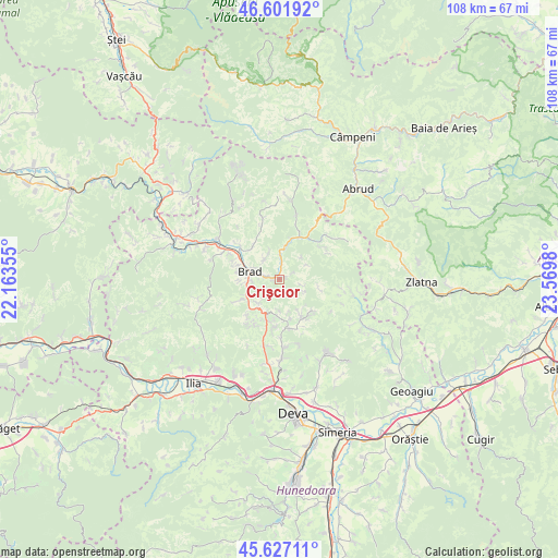
Crişcior GPS coordinates[2]
46° 7' 0.012" North, 22° 52' 0.012" East
| Map corner | latitude | longitude |
|---|---|---|
| Upper-left | 46.60192°, | 22.16355° |
| Center: | 46.11667°, | 22.86667° |
| Lower-right: | 45.62711°, | 23.5698° |
| Map W x H: | 108.4×108.4 km | = 67.4×67.4mi |
| max Lat: | 48.23793° ⇑42.3% North |
| Crişcior: | 46.11667° |
| min Lat: | ⇓57.7% South 43.65638° |
| min Long | Crişcior | max Long |
| 20.31667° | 22.86667° | 29.65403° |
| W 13.7%⇐ | ⇒86.3% E |
Elevation
Elevation of Crişcior is 336 m = 1102 ft, and this is 81.1 m = 266 ft above average elevation for this country.
| Max E: |
1278 m = 4193 ft | 27.7% |
| Crişcior | 336 m 1102 ft | |
| Avg. | 254.9 m = 836 ft | |
Min E: |
-2 m = -7 ft | 72.3% |
See also: Romania elevation on elevation.city.
Geographical zone
Crişcior is located in North temperate zone (between Tropic of Cancer and the Arctic Circle). Distance of this North polar circle is 2273.5 km =1412.7 mi to North.| Distance of | km | miles | from Crişcior |
|---|---|---|---|
| North Pole | 4879.4 | 3031.9 | to North |
| Arctic Circle | 2273.5 | 1412.7 | to North |
| Tropic Cancer | 2521.8 | 1567 | to South |
| Equator | 5127.7 | 3186.2 | to South |


Nearby cities:
15 places around Crişcior: (largest is in red/bold)
• Barza
0.8 km =0.5 mi,  295°
295°
• Brad
6.7 km =4.2 mi,  286°
286°
• Bucureşci
3.2 km =2 mi,  54°
54°
• Crișan
8 km =5 mi,  318°
318°
• Hărțăgani
8.5 km =5.3 mi,  150°
150°
• Luncoiu de Jos
7.9 km =4.9 mi,  256°
256°
• Luncoiu de Sus
6.1 km =3.8 mi,  222°
222°
• Mesteacăn
8.5 km =5.3 mi, 290°
• Mihăileni
7.9 km =4.9 mi,  16°
16°
• Ormindea
7 km =4.3 mi,  183°
183°
• Valea Bradului
4.8 km =3 mi, 322°
• Vălişoara
7.5 km =4.7 mi,  189°
189°
• Zdrapți
4.4 km =2.7 mi,  2°
2°
• Șesuri
5.1 km =3.2 mi,  115°
115°
• Țărățel
3.7 km =2.3 mi,  280°
280°
Sources, notices
• [Note1] Compared only with cities in Romania existing in our database
• [Src1] Map data: © OpenStreetMap contributors (CC-BY-SA)
• [Src2] Other city data from geonames.org with taken over terms of usage.
• [Src3] Geographical zone / Annual Mean Temperature by Robert A. Rohde @ Wikipedia
