Albeşti geodata
Albeşti (Constanța) is a seat of a second-order administrative division; located in Romania in Europe/Bucharest (GMT+3) time zone. With population of 3,459 people, there are 1451 cities with bigger population in this country. Compared to other cities in Romania, 99.5% of cities are located further ↑North; 98.4% of cities are located further ←West and 92.2% of cities have higher elevation than Albeşti. Note1


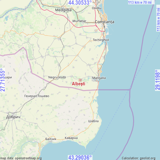
Albeşti GPS coordinates[2]
43° 48' 0" North, 28° 25' 0.012" East
| Map corner | latitude | longitude |
|---|---|---|
| Upper-left | 44.30533°, | 27.71355° |
| Center: | 43.8°, | 28.41667° |
| Lower-right: | 43.29036°, | 29.1198° |
| Map W x H: | 112.9×112.9 km | = 70.2×70.2mi |
| max Lat: | 48.23793° ⇑99.5% North |
| Albeşti: | 43.8° |
| min Lat: | ⇓0.5% South 43.65638° |
| min Long | Albeşti | max Long |
| 20.31667° | 28.41667° | 29.65403° |
| W 98.4%⇐ | ⇒1.6% E |
Elevation
Elevation of Albeşti is 48 m = 157 ft, and this is 206.9 m = 679 ft below average elevation for this country.
| Max E: |
1278 m = 4193 ft | 92.2% |
| Avg. | 254.9 m = 836 ft | |
| Albeşti | 48 m = 157 ft | |
Min E: |
-2 m = -7 ft | 7.8% |
See also: Romania elevation on elevation.city.
Geographical zone
Albeşti is located in North temperate zone (between Tropic of Cancer and the Arctic Circle). Distance of this Northern Tropic circle is 2264.2 km =1406.9 mi to South.| Distance of | km | miles | from Albeşti |
|---|---|---|---|
| North Pole | 5137 | 3192 | to North |
| Arctic Circle | 2531.1 | 1572.8 | to North |
| Tropic Cancer | 2264.2 | 1406.9 | to South |
| Equator | 4870.1 | 3026.1 | to South |


Nearby cities:
15 places around Albeşti: (largest is in red/bold)
• 23 August
18.6 km =11.6 mi,  45°
45°
• Amzacea
16.7 km =10.4 mi,  355°
355°
• Arsa
5.8 km =3.6 mi,  41°
41°
• Chirnogeni
18.4 km =11.4 mi,  307°
307°
• Comana
13.7 km =8.5 mi,  324°
324°
• Cotu Văii
6.2 km =3.9 mi,  294°
294°
• Darabani
9.7 km =6 mi,  261°
261°
• Dulcești
15.7 km =9.8 mi, 42°
• Limanu
9.4 km =5.8 mi,  90°
90°
• Mangalia
13.4 km =8.3 mi, 90°
• Moșneni
17.6 km =10.9 mi,  31°
31°
• Negru Vodă
17.5 km =10.9 mi,  276°
276°
• Neptun
16.8 km =10.4 mi,  61°
61°
• Pecineaga
13 km =8.1 mi, 31°
• Tătaru
10 km =6.2 mi,  333°
333°
Sources, notices
• [Note1] Compared only with cities in Romania existing in our database
• [Src1] Map data: © OpenStreetMap contributors (CC-BY-SA)
• [Src2] Other city data from geonames.org with taken over terms of usage.
• [Src3] Geographical zone / Annual Mean Temperature by Robert A. Rohde @ Wikipedia
